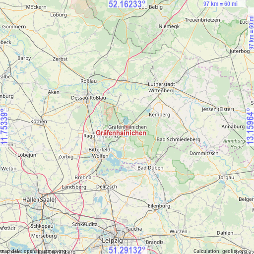
Gräfenhainichen geodata
Gräfenhainichen (Saxony-Anhalt) is a populated place; located in Germany in Europe/Berlin (GMT+2) time zone. With population of 7,833 people, there are 1983 cities with bigger population in this country. Compared to other cities in Germany, 69.1% of cities are located further ↓South; 87.6% of cities are located further ←West and 69.8% of cities have higher elevation than Gräfenhainichen. Note1
Administrative division(s):
- Level 1: Saxony-Anhalt
- Level 3: Landkreis Wittenberg
- Level 4: Gräfenhainichen


Gräfenhainichen GPS coordinates[2]
51° 43' 44.112" North, 12° 27' 23.436" East
| Map corner | latitude | longitude |
|---|---|---|
| Upper-left | 52.16233°, | 11.75339° |
| Center: | 51.72892°, | 12.45651° |
| Lower-right: | 51.29132°, | 13.15964° |
| Map W x H: | 96.8×96.8 km | = 60.1×60.1mi |
| max Lat: | 55.01917° ⇑30.9% North |
| Gräfenhainichen: | 51.72892° |
| min Lat: | ⇓69.1% South 47.40724° |
| min Long | Gräfenhainiche | max Long |
| 5.92978° | 12.45651° | 14.98853° |
| W 87.6%⇐ | ⇒12.4% E |
Elevation
Elevation of Gräfenhainichen is 92 m = 302 ft, and this is 157.1 m = 515 ft below average elevation for this country.
| Max E: |
1256 m = 4121 ft | 69.8% |
| Avg. | 249.1 m = 817 ft | |
| Gräfenhainichen | 92 m = 302 ft | |
Min E: |
-5 m = -16 ft | 30.2% |
See also: Germany elevation on elevation.city.
Geographical zone
Gräfenhainichen is located in North temperate zone (between Tropic of Cancer and the Arctic Circle). Distance of this North polar circle is 1649.5 km =1025 mi to North.| Distance of | km | miles | from Gräfenhainichen |
|---|---|---|---|
| North Pole | 4255.3 | 2644.1 | to North |
| Arctic Circle | 1649.5 | 1025 | to North |
| Tropic Cancer | 3145.8 | 1954.7 | to South |
| Equator | 5751.7 | 3573.9 | to South |


Nearby cities:
15 places around Gräfenhainichen: (largest is in red/bold)
• Burgkemnitz
6.3 km =3.9 mi,  217°
217°
• Gossa
6.7 km =4.2 mi,  187°
187°
• Gröbern
4.5 km =2.8 mi,  184°
184°
• Horstdorf
10.3 km =6.4 mi,  349°
349°
• Jüdenberg
3.7 km =2.3 mi,  309°
309°
• Kakau
8.5 km =5.3 mi, 349°
• Krina
8.5 km =5.3 mi,  165°
165°
• Muldenstein
9.9 km =6.2 mi,  230°
230°
• Möhlau
7.1 km =4.4 mi,  272°
272°
• Oranienbaum
8.5 km =5.3 mi,  335°
335°
• Radis
4.8 km =3 mi,  56°
56°
• Schköna
7.7 km =4.8 mi,  133°
133°
• Schlaitz
8 km =5 mi, 193°
• Schleesen
6.5 km =4 mi,  19°
19°
• Zschornewitz
4.2 km =2.6 mi,  249°
249°
Sources, notices
• [Note1] Compared only with cities in Germany existing in our database
• [Src1] Map data: © OpenStreetMap contributors (CC-BY-SA)
• [Src2] Other city data from geonames.org with taken over terms of usage.
• [Src3] Geographical zone / Annual Mean Temperature by Robert A. Rohde @ Wikipedia
