Zschornewitz geodata
Zschornewitz (Saxony-Anhalt) is a populated place; located in Germany in Europe/Berlin (GMT+2) time zone. With population of 2,936 people, there are 4057 cities with bigger population in this country. Compared to other cities in Germany, 69% of cities are located further ↓South; 87% of cities are located further ←West and 70.2% of cities have higher elevation than Zschornewitz. Note1
Administrative division(s):
- Level 1: Saxony-Anhalt
- Level 3: Landkreis Wittenberg
- Level 4: Gräfenhainichen


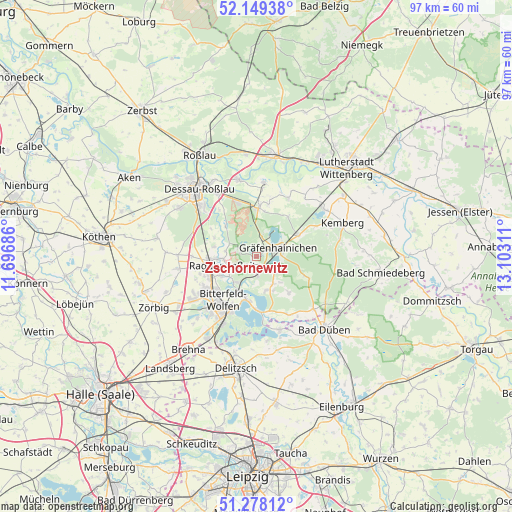
Zschornewitz GPS coordinates[2]
51° 42' 57.06" North, 12° 23' 59.928" East
| Map corner | latitude | longitude |
|---|---|---|
| Upper-left | 52.14938°, | 11.69686° |
| Center: | 51.71585°, | 12.39998° |
| Lower-right: | 51.27812°, | 13.10311° |
| Map W x H: | 96.9×96.9 km | = 60.2×60.2mi |
| max Lat: | 55.01917° ⇑31% North |
| Zschornewitz: | 51.71585° |
| min Lat: | ⇓69% South 47.40724° |
| min Long | Zschornewitz | max Long |
| 5.92978° | 12.39998° | 14.98853° |
| W 87%⇐ | ⇒13% E |
Elevation
Elevation of Zschornewitz is 90 m = 295 ft, and this is 159.1 m = 522 ft below average elevation for this country.
| Max E: |
1256 m = 4121 ft | 70.2% |
| Avg. | 249.1 m = 817 ft | |
| Zschornewitz | 90 m = 295 ft | |
Min E: |
-5 m = -16 ft | 29.8% |
See also: Germany elevation on elevation.city.
Geographical zone
Zschornewitz is located in North temperate zone (between Tropic of Cancer and the Arctic Circle). Distance of this North polar circle is 1650.9 km =1025.8 mi to North.| Distance of | km | miles | from Zschornewitz |
|---|---|---|---|
| North Pole | 4256.8 | 2645.1 | to North |
| Arctic Circle | 1650.9 | 1025.8 | to North |
| Tropic Cancer | 3144.3 | 1953.8 | to South |
| Equator | 5750.3 | 3573.1 | to South |


Nearby cities:
15 places around Zschornewitz: (largest is in red/bold)
• Burgkemnitz
3.6 km =2.2 mi,  179°
179°
• Friedersdorf
7.9 km =4.9 mi,  197°
197°
• Gossa
6 km =3.7 mi,  149°
149°
• Gräfenhainichen
4.2 km =2.6 mi,  69°
69°
• Gröbern
4.7 km =2.9 mi,  130°
130°
• Jeßnitz
7.8 km =4.8 mi,  242°
242°
• Jüdenberg
4 km =2.5 mi,  14°
14°
• Krina
9.1 km =5.7 mi,  138°
138°
• Muldenstein
6.2 km =3.9 mi,  217°
217°
• Möhlau
3.7 km =2.3 mi,  297°
297°
• Mühlbeck
8.7 km =5.4 mi,  188°
188°
• Radis
8.9 km =5.5 mi,  62°
62°
• Raguhn
8.6 km =5.3 mi,  266°
266°
• Schierau
8.8 km =5.5 mi,  294°
294°
• Schlaitz
6.6 km =4.1 mi,  162°
162°
Sources, notices
• [Note1] Compared only with cities in Germany existing in our database
• [Src1] Map data: © OpenStreetMap contributors (CC-BY-SA)
• [Src2] Other city data from geonames.org with taken over terms of usage.
• [Src3] Geographical zone / Annual Mean Temperature by Robert A. Rohde @ Wikipedia
