Krina geodata
Krina (Saxony-Anhalt) is a populated place; located in Germany in Europe/Berlin (GMT+2) time zone. With population of 756 people, there are 8067 cities with bigger population in this country. Compared to other cities in Germany, 68.3% of cities are located further ↓South; 87.9% of cities are located further ←West and 67.6% of cities have higher elevation than Krina. Note1


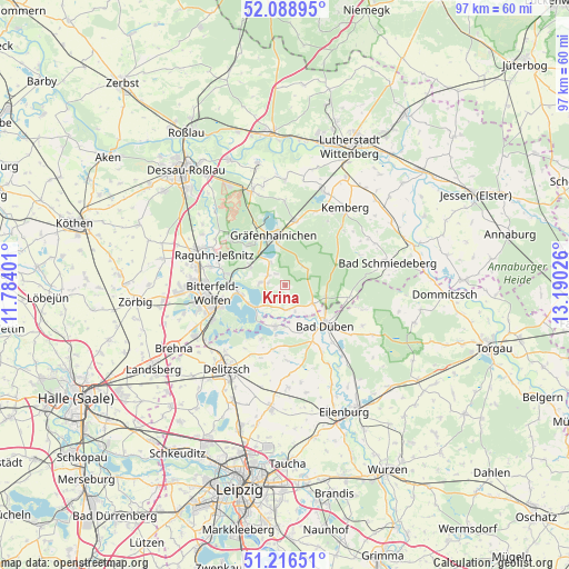
Krina GPS coordinates[2]
51° 39' 17.388" North, 12° 29' 13.668" East
| Map corner | latitude | longitude |
|---|---|---|
| Upper-left | 52.08895°, | 11.78401° |
| Center: | 51.65483°, | 12.48713° |
| Lower-right: | 51.21651°, | 13.19026° |
| Map W x H: | 97×97 km | = 60.3×60.3mi |
| max Lat: | 55.01917° ⇑31.7% North |
| Krina: | 51.65483° |
| min Lat: | ⇓68.3% South 47.40724° |
| min Long | Krina | max Long |
| 5.92978° | 12.48713° | 14.98853° |
| W 87.9%⇐ | ⇒12.1% E |
Elevation
Elevation of Krina is 104 m = 341 ft, and this is 145.1 m = 476 ft below average elevation for this country.
| Max E: |
1256 m = 4121 ft | 67.6% |
| Avg. | 249.1 m = 817 ft | |
| Krina | 104 m = 341 ft | |
Min E: |
-5 m = -16 ft | 32.4% |
See also: Germany elevation on elevation.city.
Geographical zone
Krina is located in North temperate zone (between Tropic of Cancer and the Arctic Circle). Distance of this North polar circle is 1657.7 km =1030 mi to North.| Distance of | km | miles | from Krina |
|---|---|---|---|
| North Pole | 4263.6 | 2649.3 | to North |
| Arctic Circle | 1657.7 | 1030 | to North |
| Tropic Cancer | 3137.6 | 1949.6 | to South |
| Equator | 5743.5 | 3568.8 | to South |


Nearby cities:
15 places around Krina: (largest is in red/bold)
• Bad Düben
9.7 km =6 mi,  136°
136°
• Burgkemnitz
6.8 km =4.2 mi,  298°
298°
• Friedersdorf
8.4 km =5.2 mi,  264°
264°
• Gossa
3.4 km =2.1 mi, 298°
• Gräfenhainichen
8.5 km =5.3 mi,  345°
345°
• Gröbern
4.5 km =2.8 mi,  326°
326°
• Löbnitz
7.1 km =4.4 mi,  193°
193°
• Muldenstein
10 km =6.2 mi,  281°
281°
• Mühlbeck
7.5 km =4.7 mi, 256°
• Pouch
6.9 km =4.3 mi,  239°
239°
• Rösa
4.3 km =2.7 mi,  176°
176°
• Schköna
4.5 km =2.8 mi,  49°
49°
• Schlaitz
4.1 km =2.5 mi, 276°
• Schwemsal
5.7 km =3.5 mi,  122°
122°
• Zschornewitz
9.1 km =5.7 mi,  318°
318°
Sources, notices
• [Note1] Compared only with cities in Germany existing in our database
• [Src1] Map data: © OpenStreetMap contributors (CC-BY-SA)
• [Src2] Other city data from geonames.org with taken over terms of usage.
• [Src3] Geographical zone / Annual Mean Temperature by Robert A. Rohde @ Wikipedia
