Kakau geodata
Kakau (Saxony-Anhalt) is a populated place; located in Germany in Europe/Berlin (GMT+2) time zone. With population of 634 people, there are 8623 cities with bigger population in this country. Compared to other cities in Germany, 70% of cities are located further ↓South; 87.3% of cities are located further ←West and 74.5% of cities have higher elevation than Kakau. Note1
Administrative division(s):
- Level 1: Saxony-Anhalt
- Level 3: Landkreis Wittenberg
- Level 4: Oranienbaum-Wörlitz


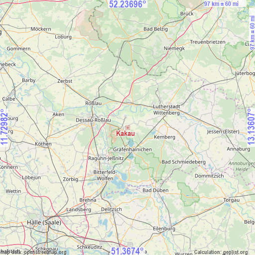
Kakau GPS coordinates[2]
51° 48' 15.408" North, 12° 25' 58.584" East
| Map corner | latitude | longitude |
|---|---|---|
| Upper-left | 52.23696°, | 11.72982° |
| Center: | 51.80428°, | 12.43294° |
| Lower-right: | 51.3674°, | 13.13607° |
| Map W x H: | 96.7×96.7 km | = 60.1×60.1mi |
| max Lat: | 55.01917° ⇑30% North |
| Kakau: | 51.80428° |
| min Lat: | ⇓70% South 47.40724° |
| min Long | Kakau | max Long |
| 5.92978° | 12.43294° | 14.98853° |
| W 87.3%⇐ | ⇒12.7% E |
Elevation
Elevation of Kakau is 65 m = 213 ft, and this is 184.1 m = 604 ft below average elevation for this country.
| Max E: |
1256 m = 4121 ft | 74.5% |
| Avg. | 249.1 m = 817 ft | |
| Kakau | 65 m = 213 ft | |
Min E: |
-5 m = -16 ft | 25.5% |
See also: Germany elevation on elevation.city.
Geographical zone
Kakau is located in North temperate zone (between Tropic of Cancer and the Arctic Circle). Distance of this North polar circle is 1641.1 km =1019.7 mi to North.| Distance of | km | miles | from Kakau |
|---|---|---|---|
| North Pole | 4247 | 2639 | to North |
| Arctic Circle | 1641.1 | 1019.7 | to North |
| Tropic Cancer | 3154.2 | 1959.9 | to South |
| Equator | 5760.1 | 3579.2 | to South |


Nearby cities:
15 places around Kakau: (largest is in red/bold)
• Apollensdorf
11.4 km =7.1 mi,  45°
45°
• Bergwitz
10.8 km =6.7 mi,  95°
95°
• Coswig
9.2 km =5.7 mi,  7°
7°
• Griebo
10 km =6.2 mi,  31°
31°
• Gräfenhainichen
8.5 km =5.3 mi,  169°
169°
• Horstdorf
1.7 km =1.1 mi,  350°
350°
• Jüdenberg
6.1 km =3.8 mi,  191°
191°
• Klieken
10.2 km =6.3 mi,  335°
335°
• Möhlau
9.8 km =6.1 mi,  214°
214°
• Oranienbaum
2 km =1.2 mi,  251°
251°
• Radis
8.1 km =5 mi,  135°
135°
• Schleesen
4.4 km =2.7 mi,  120°
120°
• Vockerode
7.3 km =4.5 mi,  310°
310°
• Wörlitz
4.2 km =2.6 mi, 348°
• Zschornewitz
10.1 km =6.3 mi, 192°
Sources, notices
• [Note1] Compared only with cities in Germany existing in our database
• [Src1] Map data: © OpenStreetMap contributors (CC-BY-SA)
• [Src2] Other city data from geonames.org with taken over terms of usage.
• [Src3] Geographical zone / Annual Mean Temperature by Robert A. Rohde @ Wikipedia
