Glasehausen geodata
Glasehausen (Thuringia) is a seat of a fourth-order administrative division; located in Germany in Europe/Berlin (GMT+2) time zone. With population of 187 people, there are 10531 cities with bigger population in this country. Compared to other cities in Germany, 65.4% of cities are located further ↓South; 52.5% of cities are located further ←West and 58.3% of cities have lower elevation than Glasehausen. Note1


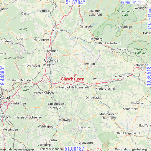
Glasehausen GPS coordinates[2]
51° 26' 32.064" North, 10° 9' 7.38" East
| Map corner | latitude | longitude |
|---|---|---|
| Upper-left | 51.8784°, | 9.44893° |
| Center: | 51.44224°, | 10.15205° |
| Lower-right: | 51.00187°, | 10.85518° |
| Map W x H: | 97.5×97.5 km | = 60.6×60.6mi |
| max Lat: | 55.01917° ⇑34.6% North |
| Glasehausen: | 51.44224° |
| min Lat: | ⇓65.4% South 47.40724° |
| min Long | Glasehausen | max Long |
| 5.92978° | 10.15205° | 14.98853° |
| W 52.5%⇐ | ⇒47.5% E |
Elevation
Elevation of Glasehausen is 280 m = 919 ft, and this is 30.9 m = 101 ft above average elevation for this country.
| Max E: |
1256 m = 4121 ft | 41.7% |
| Glasehausen | 280 m 919 ft | |
| Avg. | 249.1 m = 817 ft | |
Min E: |
-5 m = -16 ft | 58.3% |
See also: Germany elevation on elevation.city.
Geographical zone
Glasehausen is located in North temperate zone (between Tropic of Cancer and the Arctic Circle). Distance of this North polar circle is 1681.3 km =1044.7 mi to North.| Distance of | km | miles | from Glasehausen |
|---|---|---|---|
| North Pole | 4287.2 | 2663.9 | to North |
| Arctic Circle | 1681.3 | 1044.7 | to North |
| Tropic Cancer | 3113.9 | 1934.9 | to South |
| Equator | 5719.8 | 3554.1 | to South |


Nearby cities:
15 places around Glasehausen: (largest is in red/bold)
• Berlingerode
6.2 km =3.9 mi,  73°
73°
• Burgwalde
9.6 km =6 mi,  227°
227°
• Ferna
10.3 km =6.4 mi,  85°
85°
• Freienhagen
7.6 km =4.7 mi,  248°
248°
• Heilbad Heiligenstadt
7.2 km =4.5 mi,  188°
188°
• Hundeshagen
9.2 km =5.7 mi,  96°
96°
• Reinholterode
3.7 km =2.3 mi,  127°
127°
• Rohrberg
9.8 km =6.1 mi, 253°
• Schachtebich
8.5 km =5.3 mi,  236°
236°
• Siemerode
3.1 km =1.9 mi, 225°
• Steinbach
5.1 km =3.2 mi,  115°
115°
• Steinheuterode
8.8 km =5.5 mi,  222°
222°
• Teistungen
8.4 km =5.2 mi, 71°
• Uder
10.5 km =6.5 mi,  212°
212°
• Wingerode
8.4 km =5.2 mi, 133°
Sources, notices
• [Note1] Compared only with cities in Germany existing in our database
• [Src1] Map data: © OpenStreetMap contributors (CC-BY-SA)
• [Src2] Other city data from geonames.org with taken over terms of usage.
• [Src3] Geographical zone / Annual Mean Temperature by Robert A. Rohde @ Wikipedia
