Ferna geodata
Ferna (Thuringia) is a seat of a fourth-order administrative division; located in Germany in Europe/Berlin (GMT+2) time zone. With population of 601 people, there are 8817 cities with bigger population in this country. Compared to other cities in Germany, 65.5% of cities are located further ↓South; 55.3% of cities are located further ←West and 60.5% of cities have lower elevation than Ferna. Note1


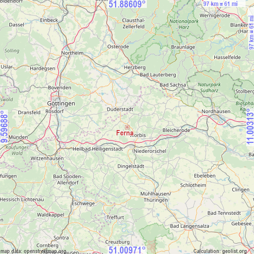
Ferna GPS coordinates[2]
51° 27' 0" North, 10° 18' 0" East
| Map corner | latitude | longitude |
|---|---|---|
| Upper-left | 51.88609°, | 9.59688° |
| Center: | 51.45°, | 10.3° |
| Lower-right: | 51.00971°, | 11.00313° |
| Map W x H: | 97.4×97.4 km | = 60.5×60.5mi |
| max Lat: | 55.01917° ⇑34.5% North |
| Ferna: | 51.45° |
| min Lat: | ⇓65.5% South 47.40724° |
| min Long | Ferna | max Long |
| 5.92978° | 10.3° | 14.98853° |
| W 55.3%⇐ | ⇒44.7% E |
Elevation
Elevation of Ferna is 293 m = 961 ft, and this is 43.9 m = 144 ft above average elevation for this country.
| Max E: |
1256 m = 4121 ft | 39.5% |
| Ferna | 293 m 961 ft | |
| Avg. | 249.1 m = 817 ft | |
Min E: |
-5 m = -16 ft | 60.5% |
See also: Germany elevation on elevation.city.
Geographical zone
Ferna is located in North temperate zone (between Tropic of Cancer and the Arctic Circle). Distance of this North polar circle is 1680.5 km =1044.2 mi to North.| Distance of | km | miles | from Ferna |
|---|---|---|---|
| North Pole | 4286.4 | 2663.4 | to North |
| Arctic Circle | 1680.5 | 1044.2 | to North |
| Tropic Cancer | 3114.8 | 1935.4 | to South |
| Equator | 5720.7 | 3554.7 | to South |


Nearby cities:
15 places around Ferna: (largest is in red/bold)
• Berlingerode
4.4 km =2.7 mi,  281°
281°
• Brehme
6.4 km =4 mi,  39°
39°
• Duderstadt
7.6 km =4.7 mi,  338°
338°
• Ecklingerode
5.7 km =3.5 mi,  11°
11°
• Holungen
8 km =5 mi,  54°
54°
• Hundeshagen
2.2 km =1.4 mi,  211°
211°
• Kirchworbis
7.9 km =4.9 mi,  122°
122°
• Leinefelde-Worbis
7.1 km =4.4 mi,  165°
165°
• Steinbach
6.4 km =4 mi,  241°
241°
• Tastungen
2.2 km =1.4 mi,  17°
17°
• Teistungen
3 km =1.9 mi,  308°
308°
• Wehnde
3.9 km =2.4 mi, 17°
• Wingerode
7.8 km =4.8 mi, 212°
• Wintzingerode
2.5 km =1.6 mi,  107°
107°
• Worbis
5.5 km =3.4 mi,  127°
127°
Sources, notices
• [Note1] Compared only with cities in Germany existing in our database
• [Src1] Map data: © OpenStreetMap contributors (CC-BY-SA)
• [Src2] Other city data from geonames.org with taken over terms of usage.
• [Src3] Geographical zone / Annual Mean Temperature by Robert A. Rohde @ Wikipedia
