Wünnenberg geodata
Wünnenberg (North Rhine-Westphalia) is a populated place; located in Germany in Europe/Berlin (GMT+2) time zone. With population of 12,439 people, there are 1311 cities with bigger population in this country. Compared to other cities in Germany, 66.6% of cities are located further ↓South; 69.1% of cities are located further →East and 59.8% of cities have lower elevation than Wünnenberg. Note1
Administrative division(s):
- Level 1: North Rhine-Westphalia
- Level 2: Regierungsbezirk Detmold
- Level 3: Kreis Paderborn
- Level 4: Bad Wünnenberg


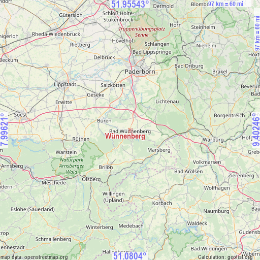
Wünnenberg GPS coordinates[2]
51° 31' 12.072" North, 8° 41' 57.624" East
| Map corner | latitude | longitude |
|---|---|---|
| Upper-left | 51.95543°, | 7.99621° |
| Center: | 51.52002°, | 8.69934° |
| Lower-right: | 51.0804°, | 9.40246° |
| Map W x H: | 97.3×97.3 km | = 60.5×60.5mi |
| max Lat: | 55.01917° ⇑33.4% North |
| Wünnenberg: | 51.52002° |
| min Lat: | ⇓66.6% South 47.40724° |
| min Long | Wünnenberg | max Long |
| 5.92978° | 8.69934° | 14.98853° |
| W 30.9%⇐ | ⇒69.1% E |
Elevation
Elevation of Wünnenberg is 289 m = 948 ft, and this is 39.9 m = 131 ft above average elevation for this country.
| Max E: |
1256 m = 4121 ft | 40.2% |
| Wünnenberg | 289 m 948 ft | |
| Avg. | 249.1 m = 817 ft | |
Min E: |
-5 m = -16 ft | 59.8% |
See also: Germany elevation on elevation.city.
Geographical zone
Wünnenberg is located in North temperate zone (between Tropic of Cancer and the Arctic Circle). Distance of this North polar circle is 1672.7 km =1039.4 mi to North.| Distance of | km | miles | from Wünnenberg |
|---|---|---|---|
| North Pole | 4278.6 | 2658.6 | to North |
| Arctic Circle | 1672.7 | 1039.4 | to North |
| Tropic Cancer | 3122.6 | 1940.3 | to South |
| Equator | 5728.5 | 3559.5 | to South |


Nearby cities:
15 places around Wünnenberg: (largest is in red/bold)
• Altenbüren
20 km =12.4 mi,  222°
222°
• Anröchte
25.8 km =16 mi,  281°
281°
• Brilon
16.5 km =10.3 mi,  212°
212°
• Büren
10.3 km =6.4 mi,  289°
289°
• Geseke
18.7 km =11.6 mi,  315°
315°
• Lichtenau
17.4 km =10.8 mi,  51°
51°
• Marsberg
12.3 km =7.6 mi,  121°
121°
• Olsberg
23.3 km =14.5 mi, 218°
• Paderborn
22.5 km =14 mi,  9°
9°
• Rhoden
22.2 km =13.8 mi,  103°
103°
• Rüthen
18.5 km =11.5 mi,  259°
259°
• Salzkotten
18.2 km =11.3 mi,  338°
338°
• Warstein
25.7 km =16 mi,  251°
251°
• Willebadessen
26.1 km =16.2 mi,  63°
63°
• Willingen
25.9 km =16.1 mi,  193°
193°
Sources, notices
• [Note1] Compared only with cities in Germany existing in our database
• [Src1] Map data: © OpenStreetMap contributors (CC-BY-SA)
• [Src2] Other city data from geonames.org with taken over terms of usage.
• [Src3] Geographical zone / Annual Mean Temperature by Robert A. Rohde @ Wikipedia
