Geretsried geodata
Geretsried (Bavaria) is a populated place; located in Germany in Europe/Berlin (GMT+2) time zone. With population of 23,364 people, there are 637 cities with bigger population in this country. Compared to other cities in Germany, 97% of cities are located further ↑North; 74% of cities are located further ←West and 95.3% of cities have lower elevation than Geretsried. Note1
Administrative division(s):
- Level 1: Bavaria
- Level 2: Upper Bavaria
- Level 3: Landkreis Bad Tölz-Wolfratshausen
- Level 4: Geretsried


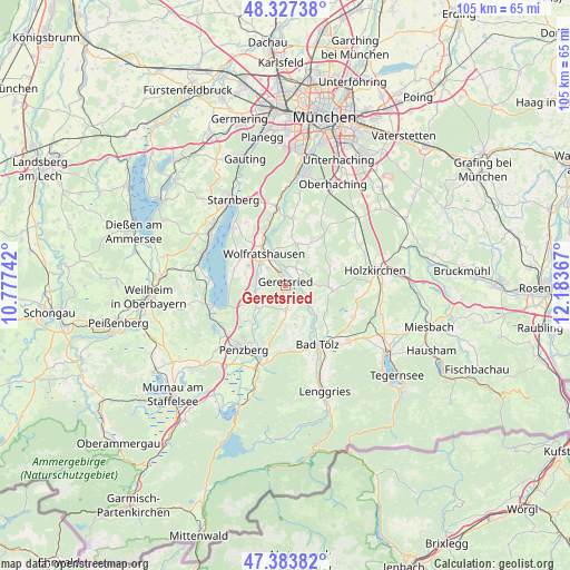
Geretsried GPS coordinates[2]
47° 51' 27.9" North, 11° 28' 49.944" East
| Map corner | latitude | longitude |
|---|---|---|
| Upper-left | 48.32738°, | 10.77742° |
| Center: | 47.85775°, | 11.48054° |
| Lower-right: | 47.38382°, | 12.18367° |
| Map W x H: | 104.9×104.9 km | = 65.2×65.2mi |
| max Lat: | 55.01917° ⇑97% North |
| Geretsried: | 47.85775° |
| min Lat: | ⇓3% South 47.40724° |
| min Long | Geretsried | max Long |
| 5.92978° | 11.48054° | 14.98853° |
| W 74%⇐ | ⇒26% E |
Elevation
Elevation of Geretsried is 607 m = 1991 ft, and this is 357.9 m = 1174 ft above average elevation for this country.
| Max E: |
1256 m = 4121 ft | 4.7% |
| Geretsried | 607 m 1991 ft | |
| Avg. | 249.1 m = 817 ft | |
Min E: |
-5 m = -16 ft | 95.3% |
See also: Germany elevation on elevation.city.
Geographical zone
Geretsried is located in North temperate zone (between Tropic of Cancer and the Arctic Circle). Distance of this North polar circle is 2079.9 km =1292.4 mi to North.| Distance of | km | miles | from Geretsried |
|---|---|---|---|
| North Pole | 4685.8 | 2911.6 | to North |
| Arctic Circle | 2079.9 | 1292.4 | to North |
| Tropic Cancer | 2715.4 | 1687.3 | to South |
| Equator | 5321.3 | 3306.5 | to South |


Nearby cities:
15 places around Geretsried: (largest is in red/bold)
• Bad Heilbrunn
12.4 km =7.7 mi,  187°
187°
• Bad Tölz
12.2 km =7.6 mi,  151°
151°
• Bernried
14 km =8.7 mi,  273°
273°
• Dietramszell
8.6 km =5.3 mi,  96°
96°
• Egling
7.5 km =4.7 mi,  14°
14°
• Eurasburg
5.6 km =3.5 mi, 265°
• Icking
10.8 km =6.7 mi,  341°
341°
• Kreut
6.6 km =4.1 mi,  178°
178°
• Königsdorf
4.7 km =2.9 mi, 179°
• Münsing
9.7 km =6 mi,  298°
298°
• Penzberg
14 km =8.7 mi,  213°
213°
• Reichertshausen
7.4 km =4.6 mi,  51°
51°
• Sachsenkam
13.5 km =8.4 mi,  115°
115°
• Seeshaupt
13.8 km =8.6 mi,  254°
254°
• Wolfratshausen
7.5 km =4.7 mi,  324°
324°
Sources, notices
• [Note1] Compared only with cities in Germany existing in our database
• [Src1] Map data: © OpenStreetMap contributors (CC-BY-SA)
• [Src2] Other city data from geonames.org with taken over terms of usage.
• [Src3] Geographical zone / Annual Mean Temperature by Robert A. Rohde @ Wikipedia
