Wolfratshausen geodata
Wolfratshausen (Bavaria) is a populated place; located in Germany in Europe/Berlin (GMT+2) time zone. With population of 17,191 people, there are 927 cities with bigger population in this country. Compared to other cities in Germany, 96.5% of cities are located further ↑North; 73% of cities are located further ←West and 94.2% of cities have lower elevation than Wolfratshausen. Note1
Administrative division(s):
- Level 1: Bavaria
- Level 2: Upper Bavaria
- Level 3: Landkreis Bad Tölz-Wolfratshausen
- Level 4: Wolfratshausen


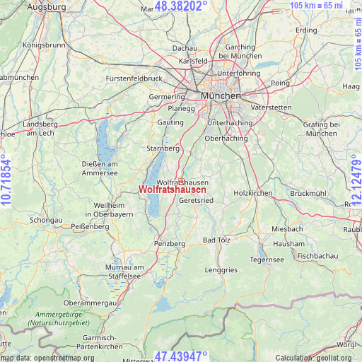
Wolfratshausen GPS coordinates[2]
47° 54' 46.404" North, 11° 25' 17.976" East
| Map corner | latitude | longitude |
|---|---|---|
| Upper-left | 48.38202°, | 10.71854° |
| Center: | 47.91289°, | 11.42166° |
| Lower-right: | 47.43947°, | 12.12479° |
| Map W x H: | 104.8×104.8 km | = 65.1×65.1mi |
| max Lat: | 55.01917° ⇑96.5% North |
| Wolfratshausen: | 47.91289° |
| min Lat: | ⇓3.5% South 47.40724° |
| min Long | Wolfratshausen | max Long |
| 5.92978° | 11.42166° | 14.98853° |
| W 73%⇐ | ⇒27% E |
Elevation
Elevation of Wolfratshausen is 578 m = 1896 ft, and this is 328.9 m = 1079 ft above average elevation for this country.
| Max E: |
1256 m = 4121 ft | 5.8% |
| Wolfratshausen | 578 m 1896 ft | |
| Avg. | 249.1 m = 817 ft | |
Min E: |
-5 m = -16 ft | 94.2% |
See also: Germany elevation on elevation.city.
Geographical zone
Wolfratshausen is located in North temperate zone (between Tropic of Cancer and the Arctic Circle). Distance of this North polar circle is 2073.8 km =1288.6 mi to North.| Distance of | km | miles | from Wolfratshausen |
|---|---|---|---|
| North Pole | 4679.6 | 2907.8 | to North |
| Arctic Circle | 2073.8 | 1288.6 | to North |
| Tropic Cancer | 2721.5 | 1691.1 | to South |
| Equator | 5327.4 | 3310.3 | to South |


Nearby cities:
15 places around Wolfratshausen: (largest is in red/bold)
• Berg
7.9 km =4.9 mi,  320°
320°
• Bernried
10.9 km =6.8 mi,  241°
241°
• Egling
6.3 km =3.9 mi,  79°
79°
• Eurasburg
6.7 km =4.2 mi,  190°
190°
• Feldafing
10.3 km =6.4 mi,  291°
291°
• Geretsried
7.5 km =4.7 mi,  144°
144°
• Icking
4.2 km =2.6 mi,  11°
11°
• Königsdorf
11.7 km =7.3 mi,  157°
157°
• Münsing
4.3 km =2.7 mi,  250°
250°
• Pöcking
10.9 km =6.8 mi,  303°
303°
• Reichertshausen
10.3 km =6.4 mi,  98°
98°
• Schäftlarn
9 km =5.6 mi,  16°
16°
• Starnberg
11.5 km =7.1 mi,  329°
329°
• Straßlach-Dingharting
12.3 km =7.6 mi,  33°
33°
• Tutzing
10.5 km =6.5 mi,  267°
267°
Sources, notices
• [Note1] Compared only with cities in Germany existing in our database
• [Src1] Map data: © OpenStreetMap contributors (CC-BY-SA)
• [Src2] Other city data from geonames.org with taken over terms of usage.
• [Src3] Geographical zone / Annual Mean Temperature by Robert A. Rohde @ Wikipedia
