Reichertshausen geodata
Reichertshausen (Bavaria) is a populated place; located in Germany in Europe/Berlin (GMT+2) time zone. With population of 4,986 people, there are 2835 cities with bigger population in this country. Compared to other cities in Germany, 96.7% of cities are located further ↑North; 75.1% of cities are located further ←West and 97.8% of cities have lower elevation than Reichertshausen. Note1
Administrative division(s):
- Level 1: Bavaria
- Level 2: Upper Bavaria
- Level 3: Landkreis Bad Tölz-Wolfratshausen
- Level 4: Egling


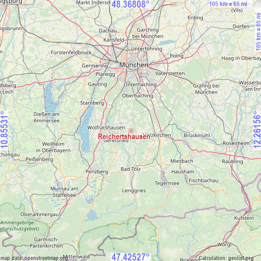
Reichertshausen GPS coordinates[2]
47° 53' 55.752" North, 11° 33' 30.348" East
| Map corner | latitude | longitude |
|---|---|---|
| Upper-left | 48.36808°, | 10.85531° |
| Center: | 47.89882°, | 11.55843° |
| Lower-right: | 47.42527°, | 12.26156° |
| Map W x H: | 104.8×104.8 km | = 65.1×65.1mi |
| max Lat: | 55.01917° ⇑96.7% North |
| Reichertshausen: | 47.89882° |
| min Lat: | ⇓3.3% South 47.40724° |
| min Long | Reichertshausen | max Long |
| 5.92978° | 11.55843° | 14.98853° |
| W 75.1%⇐ | ⇒24.9% E |
Elevation
Elevation of Reichertshausen is 698 m = 2290 ft, and this is 448.9 m = 1473 ft above average elevation for this country.
| Max E: |
1256 m = 4121 ft | 2.2% |
| Reichertshausen | 698 m 2290 ft | |
| Avg. | 249.1 m = 817 ft | |
Min E: |
-5 m = -16 ft | 97.8% |
See also: Germany elevation on elevation.city.
Geographical zone
Reichertshausen is located in North temperate zone (between Tropic of Cancer and the Arctic Circle). Distance of this North polar circle is 2075.3 km =1289.5 mi to North.| Distance of | km | miles | from Reichertshausen |
|---|---|---|---|
| North Pole | 4681.2 | 2908.8 | to North |
| Arctic Circle | 2075.3 | 1289.5 | to North |
| Tropic Cancer | 2719.9 | 1690.1 | to South |
| Equator | 5325.8 | 3309.3 | to South |


Nearby cities:
15 places around Reichertshausen: (largest is in red/bold)
• Dietramszell
6.2 km =3.9 mi,  153°
153°
• Egling
4.8 km =3 mi,  304°
304°
• Eurasburg
12.4 km =7.7 mi,  246°
246°
• Geretsried
7.4 km =4.6 mi,  231°
231°
• Holzkirchen
11 km =6.8 mi,  102°
102°
• Icking
10.9 km =6.8 mi, 301°
• Kreut
12.5 km =7.8 mi,  206°
206°
• Königsdorf
10.9 km =6.8 mi, 212°
• Oberhaching
14.3 km =8.9 mi,  11°
11°
• Otterfing
8.8 km =5.5 mi,  82°
82°
• Sachsenkam
12.2 km =7.6 mi, 148°
• Sauerlach
10.8 km =6.7 mi,  41°
41°
• Schäftlarn
12.7 km =7.9 mi,  323°
323°
• Straßlach-Dingharting
12.2 km =7.6 mi,  344°
344°
• Wolfratshausen
10.3 km =6.4 mi,  278°
278°
Sources, notices
• [Note1] Compared only with cities in Germany existing in our database
• [Src1] Map data: © OpenStreetMap contributors (CC-BY-SA)
• [Src2] Other city data from geonames.org with taken over terms of usage.
• [Src3] Geographical zone / Annual Mean Temperature by Robert A. Rohde @ Wikipedia
