Eurasburg geodata
Eurasburg (Bavaria) is a seat of a fourth-order administrative division; located in Germany in Europe/Berlin (GMT+2) time zone. With population of 4,397 people, there are 3096 cities with bigger population in this country. Compared to other cities in Germany, 97.1% of cities are located further ↑North; 72.7% of cities are located further ←West and 94.4% of cities have lower elevation than Eurasburg. Note1
Administrative division(s):
- Level 1: Bavaria
- Level 2: Upper Bavaria
- Level 3: Landkreis Bad Tölz-Wolfratshausen
- Level 4: Eurasburg


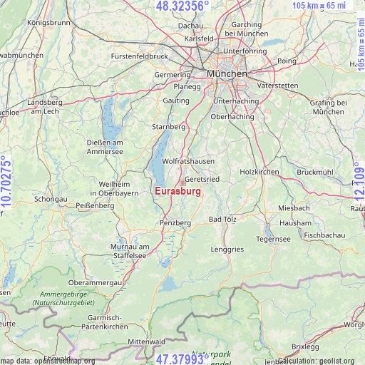
Eurasburg GPS coordinates[2]
47° 51' 14.004" North, 11° 24' 21.132" East
| Map corner | latitude | longitude |
|---|---|---|
| Upper-left | 48.32356°, | 10.70275° |
| Center: | 47.85389°, | 11.40587° |
| Lower-right: | 47.37993°, | 12.109° |
| Map W x H: | 104.9×104.9 km | = 65.2×65.2mi |
| max Lat: | 55.01917° ⇑97.1% North |
| Eurasburg: | 47.85389° |
| min Lat: | ⇓2.9% South 47.40724° |
| min Long | Eurasburg | max Long |
| 5.92978° | 11.40587° | 14.98853° |
| W 72.7%⇐ | ⇒27.3% E |
Elevation
Elevation of Eurasburg is 586 m = 1923 ft, and this is 336.9 m = 1105 ft above average elevation for this country.
| Max E: |
1256 m = 4121 ft | 5.6% |
| Eurasburg | 586 m 1923 ft | |
| Avg. | 249.1 m = 817 ft | |
Min E: |
-5 m = -16 ft | 94.4% |
See also: Germany elevation on elevation.city.
Geographical zone
Eurasburg is located in North temperate zone (between Tropic of Cancer and the Arctic Circle). Distance of this North polar circle is 2080.3 km =1292.6 mi to North.| Distance of | km | miles | from Eurasburg |
|---|---|---|---|
| North Pole | 4686.2 | 2911.9 | to North |
| Arctic Circle | 2080.3 | 1292.6 | to North |
| Tropic Cancer | 2714.9 | 1687 | to South |
| Equator | 5320.9 | 3306.3 | to South |


Nearby cities:
15 places around Eurasburg: (largest is in red/bold)
• Bad Heilbrunn
12.6 km =7.8 mi,  161°
161°
• Bernried
8.5 km =5.3 mi,  279°
279°
• Egling
10.7 km =6.6 mi,  43°
43°
• Feldafing
13.2 km =8.2 mi,  320°
320°
• Geretsried
5.6 km =3.5 mi,  85°
85°
• Icking
10.9 km =6.8 mi,  10°
10°
• Iffeldorf
11.8 km =7.3 mi,  214°
214°
• Kreut
8.4 km =5.2 mi,  136°
136°
• Königsdorf
7 km =4.3 mi,  127°
127°
• Münsing
5.9 km =3.7 mi,  330°
330°
• Penzberg
11.4 km =7.1 mi,  190°
190°
• Reichertshausen
12.4 km =7.7 mi,  66°
66°
• Seeshaupt
8.4 km =5.2 mi,  247°
247°
• Tutzing
11.2 km =7 mi,  303°
303°
• Wolfratshausen
6.7 km =4.2 mi, 10°
Sources, notices
• [Note1] Compared only with cities in Germany existing in our database
• [Src1] Map data: © OpenStreetMap contributors (CC-BY-SA)
• [Src2] Other city data from geonames.org with taken over terms of usage.
• [Src3] Geographical zone / Annual Mean Temperature by Robert A. Rohde @ Wikipedia
