Lahr geodata
Lahr (Baden-Württemberg) is a populated place; located in Germany in Europe/Berlin (GMT+2) time zone. With population of 43,863 people, there are 274 cities with bigger population in this country. Compared to other cities in Germany, 90.8% of cities are located further ↑North; 79.5% of cities are located further →East and 56.8% of cities have higher elevation than Lahr. Note1
Administrative division(s):
- Level 1: Baden-Württemberg
- Level 2: Freiburg Region
- Level 3: Ortenaukreis
- Level 4: Lahr/Schwarzwald


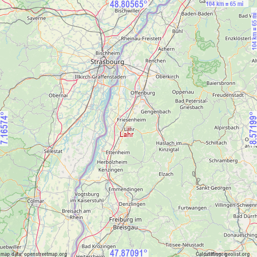
Lahr GPS coordinates[2]
48° 20' 25.512" North, 7° 52' 7.896" East
| Map corner | latitude | longitude |
|---|---|---|
| Upper-left | 48.80565°, | 7.16574° |
| Center: | 48.34042°, | 7.86886° |
| Lower-right: | 47.87091°, | 8.57199° |
| Map W x H: | 103.9×103.9 km | = 64.6×64.6mi |
| max Lat: | 55.01917° ⇑90.8% North |
| Lahr: | 48.34042° |
| min Lat: | ⇓9.2% South 47.40724° |
| min Long | Lahr | max Long |
| 5.92978° | 7.86886° | 14.98853° |
| W 20.5%⇐ | ⇒79.5% E |
Elevation
Elevation of Lahr is 176 m = 577 ft, and this is 73.1 m = 240 ft below average elevation for this country.
| Max E: |
1256 m = 4121 ft | 56.8% |
| Avg. | 249.1 m = 817 ft | |
| Lahr | 176 m = 577 ft | |
Min E: |
-5 m = -16 ft | 43.2% |
See also: Lahr elevation on elevation.city.
Geographical zone
Lahr is located in North temperate zone (between Tropic of Cancer and the Arctic Circle). Distance of this North polar circle is 2026.2 km =1259 mi to North.| Distance of | km | miles | from Lahr |
|---|---|---|---|
| North Pole | 4632.1 | 2878.3 | to North |
| Arctic Circle | 2026.2 | 1259 | to North |
| Tropic Cancer | 2769 | 1720.6 | to South |
| Equator | 5375 | 3339.9 | to South |


Nearby cities:
15 places around Lahr: (largest is in red/bold)
• Berghaupten
11.4 km =7.1 mi,  50°
50°
• Biberach
12.2 km =7.6 mi,  93°
93°
• Ettenheim
10.2 km =6.3 mi,  204°
204°
• Friesenheim
3.1 km =1.9 mi,  20°
20°
• Grafenhausen
9.8 km =6.1 mi,  230°
230°
• Hohberg
3 km =1.9 mi,  130°
130°
• Kappel-Grafenhausen
9.9 km =6.2 mi, 230°
• Kippenheim
5.9 km =3.7 mi,  213°
213°
• Mahlberg
7.2 km =4.5 mi, 213°
• Meißenheim
10.5 km =6.5 mi,  317°
317°
• Ringsheim
12.3 km =7.6 mi, 213°
• Schuttertal
10.2 km =6.3 mi,  143°
143°
• Schutterwald
12.2 km =7.6 mi,  5°
5°
• Schwanau
8.4 km =5.2 mi,  290°
290°
• Seelbach
6.3 km =3.9 mi,  122°
122°
In other languages:
- In France: Lahr/Schwarzwald
- In German: Lahr/Schwarzwald
- In Italian: Lahr/Schwarzwald
- In Russian: Лар
- In Chinese: 拉尔
Sources, notices
• [Note1] Compared only with cities in Germany existing in our database
• [Src1] Map data: © OpenStreetMap contributors (CC-BY-SA)
• [Src2] Other city data from geonames.org with taken over terms of usage.
• [Src3] Geographical zone / Annual Mean Temperature by Robert A. Rohde @ Wikipedia
