Hohberg geodata
Hohberg (Baden-Württemberg) is a populated locality; located in Germany in Europe/Berlin (GMT+2) time zone. With population of 7,809 people, there are 1987 cities with bigger population in this country. Compared to other cities in Germany, 91% of cities are located further ↑North; 79% of cities are located further →East and 68.1% of cities have lower elevation than Hohberg. Note1
Administrative division(s):
- Level 1: Baden-Württemberg
- Level 2: Freiburg Region
- Level 3: Ortenaukreis
- Level 4: Lahr/Schwarzwald


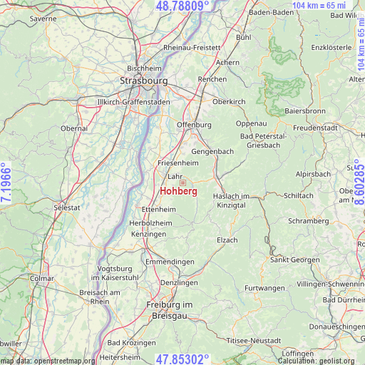
Hohberg GPS coordinates[2]
48° 19' 21.72" North, 7° 53' 58.992" East
| Map corner | latitude | longitude |
|---|---|---|
| Upper-left | 48.78809°, | 7.1966° |
| Center: | 48.3227°, | 7.89972° |
| Lower-right: | 47.85302°, | 8.60285° |
| Map W x H: | 104×104 km | = 64.6×64.6mi |
| max Lat: | 55.01917° ⇑91% North |
| Hohberg: | 48.3227° |
| min Lat: | ⇓9% South 47.40724° |
| min Long | Hohberg | max Long |
| 5.92978° | 7.89972° | 14.98853° |
| W 21%⇐ | ⇒79% E |
Elevation
Elevation of Hohberg is 343 m = 1125 ft, and this is 93.9 m = 308 ft above average elevation for this country.
| Max E: |
1256 m = 4121 ft | 31.9% |
| Hohberg | 343 m 1125 ft | |
| Avg. | 249.1 m = 817 ft | |
Min E: |
-5 m = -16 ft | 68.1% |
See also: Germany elevation on elevation.city.
Geographical zone
Hohberg is located in North temperate zone (between Tropic of Cancer and the Arctic Circle). Distance of this North polar circle is 2028.2 km =1260.3 mi to North.| Distance of | km | miles | from Hohberg |
|---|---|---|---|
| North Pole | 4634.1 | 2879.5 | to North |
| Arctic Circle | 2028.2 | 1260.3 | to North |
| Tropic Cancer | 2767.1 | 1719.4 | to South |
| Equator | 5373 | 3338.6 | to South |


Nearby cities:
15 places around Hohberg: (largest is in red/bold)
• Berghaupten
11.3 km =7 mi,  34°
34°
• Biberach
9.9 km =6.2 mi,  83°
83°
• Ettenheim
9.8 km =6.1 mi,  221°
221°
• Friesenheim
5 km =3.1 mi,  346°
346°
• Gengenbach
12.4 km =7.7 mi,  42°
42°
• Grafenhausen
10.7 km =6.6 mi,  246°
246°
• Kappel-Grafenhausen
10.8 km =6.7 mi, 246°
• Kippenheim
6.3 km =3.9 mi,  241°
241°
• Lahr
3 km =1.9 mi,  310°
310°
• Mahlberg
7.5 km =4.7 mi, 237°
• Ringsheim
12.3 km =7.6 mi,  227°
227°
• Schuttertal
7.3 km =4.5 mi,  149°
149°
• Schwanau
11.3 km =7 mi,  295°
295°
• Seelbach
3.3 km =2.1 mi,  114°
114°
• Steinach
11.4 km =7.1 mi,  102°
102°
Sources, notices
• [Note1] Compared only with cities in Germany existing in our database
• [Src1] Map data: © OpenStreetMap contributors (CC-BY-SA)
• [Src2] Other city data from geonames.org with taken over terms of usage.
• [Src3] Geographical zone / Annual Mean Temperature by Robert A. Rohde @ Wikipedia
