Langenselbold geodata
Langenselbold (Hesse) is a populated place; located in Germany in Europe/Berlin (GMT+2) time zone. With population of 12,660 people, there are 1279 cities with bigger population in this country. Compared to other cities in Germany, 59.5% of cities are located further ↑North; 64.9% of cities are located further →East and 64.5% of cities have higher elevation than Langenselbold. Note1
Administrative division(s):
- Level 1: Hesse
- Level 2: Regierungsbezirk Darmstadt
- Level 3: Main-Kinzig-Kreis
- Level 4: Langenselbold


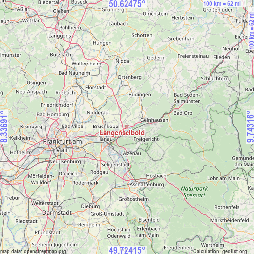
Langenselbold GPS coordinates[2]
50° 10' 35.652" North, 9° 2' 24.108" East
| Map corner | latitude | longitude |
|---|---|---|
| Upper-left | 50.62475°, | 8.33691° |
| Center: | 50.17657°, | 9.04003° |
| Lower-right: | 49.72415°, | 9.74316° |
| Map W x H: | 100.1×100.1 km | = 62.2×62.2mi |
| max Lat: | 55.01917° ⇑59.5% North |
| Langenselbold: | 50.17657° |
| min Lat: | ⇓40.5% South 47.40724° |
| min Long | Langenselbold | max Long |
| 5.92978° | 9.04003° | 14.98853° |
| W 35.1%⇐ | ⇒64.9% E |
Elevation
Elevation of Langenselbold is 124 m = 407 ft, and this is 125.1 m = 410 ft below average elevation for this country.
| Max E: |
1256 m = 4121 ft | 64.5% |
| Avg. | 249.1 m = 817 ft | |
| Langenselbold | 124 m = 407 ft | |
Min E: |
-5 m = -16 ft | 35.5% |
See also: Germany elevation on elevation.city.
Geographical zone
Langenselbold is located in North temperate zone (between Tropic of Cancer and the Arctic Circle). Distance of this North polar circle is 1822.1 km =1132.2 mi to North.| Distance of | km | miles | from Langenselbold |
|---|---|---|---|
| North Pole | 4428 | 2751.4 | to North |
| Arctic Circle | 1822.1 | 1132.2 | to North |
| Tropic Cancer | 2973.2 | 1847.5 | to South |
| Equator | 5579.1 | 3466.7 | to South |


Nearby cities:
15 places around Langenselbold: (largest is in red/bold)
• Altenstadt
14.1 km =8.8 mi,  330°
330°
• Alzenau in Unterfranken
9.9 km =6.2 mi,  169°
169°
• Bruchköbel
8.3 km =5.2 mi,  271°
271°
• Büdingen
13.6 km =8.5 mi,  21°
21°
• Erlensee
4.7 km =2.9 mi,  251°
251°
• Geiselbach
12.6 km =7.8 mi,  117°
117°
• Gelnhausen
10.9 km =6.8 mi,  75°
75°
• Großkrotzenburg
11.1 km =6.9 mi,  201°
201°
• Hain-Gründau
10.4 km =6.5 mi,  44°
44°
• Hammersbach
6 km =3.7 mi,  317°
317°
• Hanau am Main
10.1 km =6.3 mi,  242°
242°
• Kahl am Main
12.1 km =7.5 mi,  191°
191°
• Nidderau
14.1 km =8.8 mi,  299°
299°
• Nieder-Gründau
6.2 km =3.9 mi,  51°
51°
• Rodenbach
3 km =1.9 mi, 189°
Sources, notices
• [Note1] Compared only with cities in Germany existing in our database
• [Src1] Map data: © OpenStreetMap contributors (CC-BY-SA)
• [Src2] Other city data from geonames.org with taken over terms of usage.
• [Src3] Geographical zone / Annual Mean Temperature by Robert A. Rohde @ Wikipedia
