Mallersdorf-Pfaffenberg geodata
Mallersdorf-Pfaffenberg (Bavaria) is a populated place; located in Germany in Europe/Berlin (GMT+2) time zone. With population of 6,742 people, there are 2248 cities with bigger population in this country. Compared to other cities in Germany, 85.7% of cities are located further ↑North; 85.1% of cities are located further ←West and 73.1% of cities have lower elevation than Mallersdorf-Pfaffenberg. Note1
Administrative division(s):
- Level 1: Bavaria
- Level 2: Lower Bavaria
- Level 3: Landkreis Straubing-Bogen
- Level 4: Mallersdorf-Pfaffenberg, Markt
Current local time in Mallersdorf-Pfaffenberg:
08:56 AM, SaturdayDifference from your time zone: hours


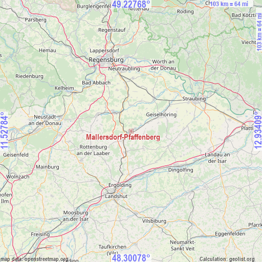
Mallersdorf-Pfaffenberg GPS coordinates[2]
48° 45' 58.932" North, 12° 13' 51.456" East
| Map corner | latitude | longitude |
|---|---|---|
| Upper-left | 49.22768°, | 11.52784° |
| Center: | 48.76637°, | 12.23096° |
| Lower-right: | 48.30078°, | 12.93409° |
| Map W x H: | 103.1×103.1 km | = 64.1×64.1mi |
| max Lat: | 55.01917° ⇑85.7% North |
| Mallersdorf-Pfaffenberg: | 48.76637° |
| min Lat: | ⇓14.3% South 47.40724° |
| min Long | Mallersdorf-Pfa | max Long |
| 5.92978° | 12.23096° | 14.98853° |
| W 85.1%⇐ | ⇒14.9% E |
Elevation
Elevation of Mallersdorf-Pfaffenberg is 383 m = 1257 ft, and this is 133.9 m = 439 ft above average elevation for this country.
| Max E: |
1256 m = 4121 ft | 26.9% |
| Mallersdorf-Pfaffenberg | 383 m 1257 ft | |
| Avg. | 249.1 m = 817 ft | |
Min E: |
-5 m = -16 ft | 73.1% |
See also: Germany elevation on elevation.city.
Geographical zone
Mallersdorf-Pfaffenberg is located in North temperate zone (between Tropic of Cancer and the Arctic Circle). Distance of this North polar circle is 1978.9 km =1229.6 mi to North.| Distance of | km | miles | from Mallersdorf-Pfaffenberg |
|---|---|---|---|
| North Pole | 4584.7 | 2848.8 | to North |
| Arctic Circle | 1978.9 | 1229.6 | to North |
| Tropic Cancer | 2816.4 | 1750 | to South |
| Equator | 5422.3 | 3369.3 | to South |


Nearby cities:
15 places around Mallersdorf-Pfaffenberg: (largest is in red/bold)
• Aufhausen
12.3 km =7.6 mi,  17°
17°
• Bayerbach
8.4 km =5.2 mi,  144°
144°
• Buch
13.6 km =8.5 mi,  201°
201°
• Ergoldsbach
8.4 km =5.2 mi,  193°
193°
• Geiselhöring
13.8 km =8.6 mi,  61°
61°
• Hagelstadt
14.9 km =9.3 mi,  355°
355°
• Herrngiersdorf
11.9 km =7.4 mi,  281°
281°
• Hohenthann
15.5 km =9.6 mi,  220°
220°
• Laberweinting
7.3 km =4.5 mi, 59°
• Langquaid
14.6 km =9.1 mi,  295°
295°
• Pfakofen
10.2 km =6.3 mi, 358°
• Postau
15 km =9.3 mi,  149°
149°
• Schierling
10.1 km =6.3 mi,  318°
318°
• Sünching
15.3 km =9.5 mi,  35°
35°
• Weng
15.7 km =9.8 mi, 139°
Sources, notices
• [Note1] Compared only with cities in Germany existing in our database
• [Src1] Map data: © OpenStreetMap contributors (CC-BY-SA)
• [Src2] Other city data from geonames.org with taken over terms of usage.
• [Src3] Geographical zone / Annual Mean Temperature by Robert A. Rohde @ Wikipedia
