Gehren geodata
Gehren (Thuringia) is a populated place; located in Germany in Europe/Berlin (GMT+2) time zone. With population of 3,703 people, there are 3474 cities with bigger population in this country. Compared to other cities in Germany, 50.7% of cities are located further ↓South; 67% of cities are located further ←West and 86.3% of cities have lower elevation than Gehren. Note1


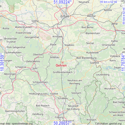
Gehren GPS coordinates[2]
50° 38' 54.672" North, 11° 0' 16.956" East
| Map corner | latitude | longitude |
|---|---|---|
| Upper-left | 51.09224°, | 10.30159° |
| Center: | 50.64852°, | 11.00471° |
| Lower-right: | 50.20057°, | 11.70784° |
| Map W x H: | 99.1×99.1 km | = 61.6×61.6mi |
| max Lat: | 55.01917° ⇑49.3% North |
| Gehren: | 50.64852° |
| min Lat: | ⇓50.7% South 47.40724° |
| min Long | Gehren | max Long |
| 5.92978° | 11.00471° | 14.98853° |
| W 67%⇐ | ⇒33% E |
Elevation
Elevation of Gehren is 480 m = 1575 ft, and this is 230.9 m = 758 ft above average elevation for this country.
| Max E: |
1256 m = 4121 ft | 13.7% |
| Gehren | 480 m 1575 ft | |
| Avg. | 249.1 m = 817 ft | |
Min E: |
-5 m = -16 ft | 86.3% |
See also: Germany elevation on elevation.city.
Geographical zone
Gehren is located in North temperate zone (between Tropic of Cancer and the Arctic Circle). Distance of this North polar circle is 1769.6 km =1099.6 mi to North.| Distance of | km | miles | from Gehren |
|---|---|---|---|
| North Pole | 4375.5 | 2718.8 | to North |
| Arctic Circle | 1769.6 | 1099.6 | to North |
| Tropic Cancer | 3025.7 | 1880.1 | to South |
| Equator | 5631.6 | 3499.3 | to South |


Nearby cities:
15 places around Gehren: (largest is in red/bold)
• Böhlen
7.3 km =4.5 mi,  157°
157°
• Dröbischau
5.2 km =3.2 mi,  113°
113°
• Friedersdorf
5.3 km =3.3 mi, 155°
• Gillersdorf
3.6 km =2.2 mi,  166°
166°
• Großbreitenbach
7.3 km =4.5 mi,  177°
177°
• Herschdorf
3.8 km =2.4 mi,  124°
124°
• Ilmenau
7.2 km =4.5 mi,  302°
302°
• Königsee
6.7 km =4.2 mi,  77°
77°
• Langewiesen
3.6 km =2.2 mi,  318°
318°
• Mellenbach-Glasbach
7.6 km =4.7 mi, 117°
• Möhrenbach
2.9 km =1.8 mi,  192°
192°
• Neuhaus
6.3 km =3.9 mi,  307°
307°
• Neustadt am Rennsteig
8.8 km =5.5 mi,  214°
214°
• Pennewitz
3.7 km =2.3 mi,  71°
71°
• Wildenspring
6.9 km =4.3 mi,  140°
140°
Sources, notices
• [Note1] Compared only with cities in Germany existing in our database
• [Src1] Map data: © OpenStreetMap contributors (CC-BY-SA)
• [Src2] Other city data from geonames.org with taken over terms of usage.
• [Src3] Geographical zone / Annual Mean Temperature by Robert A. Rohde @ Wikipedia
