Gehlert geodata
Gehlert (Rheinland-Pfalz) is a seat of a fourth-order administrative division; located in Germany in Europe/Berlin (GMT+2) time zone. With population of 559 people, there are 9033 cities with bigger population in this country. Compared to other cities in Germany, 50.5% of cities are located further ↓South; 80.5% of cities are located further →East and 75.2% of cities have lower elevation than Gehlert. Note1


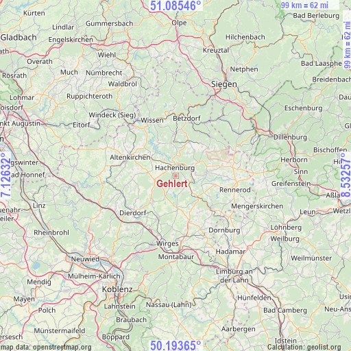
Gehlert GPS coordinates[2]
50° 38' 30.012" North, 7° 49' 45.984" East
| Map corner | latitude | longitude |
|---|---|---|
| Upper-left | 51.08546°, | 7.12632° |
| Center: | 50.64167°, | 7.82944° |
| Lower-right: | 50.19365°, | 8.53257° |
| Map W x H: | 99.2×99.2 km | = 61.6×61.6mi |
| max Lat: | 55.01917° ⇑49.5% North |
| Gehlert: | 50.64167° |
| min Lat: | ⇓50.5% South 47.40724° |
| min Long | Gehlert | max Long |
| 5.92978° | 7.82944° | 14.98853° |
| W 19.5%⇐ | ⇒80.5% E |
Elevation
Elevation of Gehlert is 399 m = 1309 ft, and this is 149.9 m = 492 ft above average elevation for this country.
| Max E: |
1256 m = 4121 ft | 24.8% |
| Gehlert | 399 m 1309 ft | |
| Avg. | 249.1 m = 817 ft | |
Min E: |
-5 m = -16 ft | 75.2% |
See also: Germany elevation on elevation.city.
Geographical zone
Gehlert is located in North temperate zone (between Tropic of Cancer and the Arctic Circle). Distance of this North polar circle is 1770.3 km =1100 mi to North.| Distance of | km | miles | from Gehlert |
|---|---|---|---|
| North Pole | 4376.2 | 2719.2 | to North |
| Arctic Circle | 1770.3 | 1100 | to North |
| Tropic Cancer | 3024.9 | 1879.6 | to South |
| Equator | 5630.8 | 3498.8 | to South |


Nearby cities:
15 places around Gehlert: (largest is in red/bold)
• Alpenrod
2.8 km =1.7 mi,  109°
109°
• Dreifelden
5.6 km =3.5 mi,  175°
175°
• Enspel
4.7 km =2.9 mi,  126°
126°
• Hachenburg
2.1 km =1.3 mi,  346°
346°
• Hattert
5.2 km =3.2 mi,  302°
302°
• Linden
4.9 km =3 mi,  162°
162°
• Lochum
4.8 km =3 mi,  147°
147°
• Merkelbach
4.2 km =2.6 mi,  275°
275°
• Müschenbach
5.7 km =3.5 mi,  324°
324°
• Nister
3.8 km =2.4 mi,  9°
9°
• Norken
5.9 km =3.7 mi,  54°
54°
• Steinebach
3.9 km =2.4 mi,  204°
204°
• Streithausen
5.9 km =3.7 mi, 350°
• Unnau
5.6 km =3.5 mi,  81°
81°
• Wied
5.1 km =3.2 mi,  266°
266°
Sources, notices
• [Note1] Compared only with cities in Germany existing in our database
• [Src1] Map data: © OpenStreetMap contributors (CC-BY-SA)
• [Src2] Other city data from geonames.org with taken over terms of usage.
• [Src3] Geographical zone / Annual Mean Temperature by Robert A. Rohde @ Wikipedia
