Steinebach geodata
Steinebach (Rheinland-Pfalz) is a populated place; located in Germany in Europe/Berlin (GMT+2) time zone. With population of 744 people, there are 8131 cities with bigger population in this country. Compared to other cities in Germany, 50.3% of cities are located further ↑North; 80.9% of cities are located further →East and 73.6% of cities have lower elevation than Steinebach. Note1
Administrative division(s):
- Level 1: Rheinland-Pfalz
- Level 3: Westerwaldkreis
- Level 4: Steinebach an der Wied


Steinebach GPS coordinates[2]
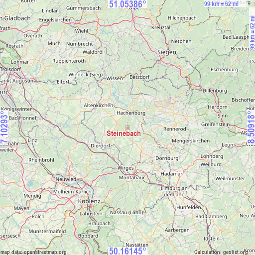
50° 36' 35.172" North, 7° 48' 21.78" East
| Map corner | latitude | longitude |
|---|---|---|
| Upper-left | 51.05386°, | 7.10293° |
| Center: | 50.60977°, | 7.80605° |
| Lower-right: | 50.16145°, | 8.50918° |
| Map W x H: | 99.2×99.2 km | = 61.6×61.6mi |
| max Lat: | 55.01917° ⇑50.3% North |
| Steinebach: | 50.60977° |
| min Lat: | ⇓49.7% South 47.40724° |
| min Long | Steinebach | max Long |
| 5.92978° | 7.80605° | 14.98853° |
| W 19.1%⇐ | ⇒80.9% E |
Elevation
Elevation of Steinebach is 387 m = 1270 ft, and this is 137.9 m = 452 ft above average elevation for this country.
| Max E: |
1256 m = 4121 ft | 26.4% |
| Steinebach | 387 m 1270 ft | |
| Avg. | 249.1 m = 817 ft | |
Min E: |
-5 m = -16 ft | 73.6% |
See also: Germany elevation on elevation.city.
Geographical zone
Steinebach is located in North temperate zone (between Tropic of Cancer and the Arctic Circle). Distance of this North polar circle is 1773.9 km =1102.3 mi to North.| Distance of | km | miles | from Steinebach |
|---|---|---|---|
| North Pole | 4379.8 | 2721.5 | to North |
| Arctic Circle | 1773.9 | 1102.3 | to North |
| Tropic Cancer | 3021.4 | 1877.4 | to South |
| Equator | 5627.3 | 3496.6 | to South |


Nearby cities:
15 places around Steinebach: (largest is in red/bold)
• Alpenrod
5 km =3.1 mi,  58°
58°
• Dreifelden
2.9 km =1.8 mi,  133°
133°
• Enspel
5.5 km =3.4 mi,  81°
81°
• Gehlert
3.9 km =2.4 mi,  24°
24°
• Hachenburg
5.7 km =3.5 mi,  11°
11°
• Hartenfels
4.2 km =2.6 mi,  198°
198°
• Höchstenbach
5.1 km =3.2 mi,  301°
301°
• Linden
3.3 km =2.1 mi,  109°
109°
• Lochum
4.3 km =2.7 mi,  96°
96°
• Merkelbach
4.7 km =2.9 mi,  327°
327°
• Mündersbach
5.1 km =3.2 mi,  265°
265°
• Rotenhain
5.6 km =3.5 mi, 101°
• Schenkelberg
3.3 km =2.1 mi,  209°
209°
• Steinen
3 km =1.9 mi,  188°
188°
• Wied
4.7 km =2.9 mi,  313°
313°
Sources, notices
• [Note1] Compared only with cities in Germany existing in our database
• [Src1] Map data: © OpenStreetMap contributors (CC-BY-SA)
• [Src2] Other city data from geonames.org with taken over terms of usage.
• [Src3] Geographical zone / Annual Mean Temperature by Robert A. Rohde @ Wikipedia
