Merkelbach geodata
Merkelbach (Rheinland-Pfalz) is a seat of a fourth-order administrative division; located in Germany in Europe/Berlin (GMT+2) time zone. With population of 381 people, there are 9750 cities with bigger population in this country. Compared to other cities in Germany, 50.6% of cities are located further ↓South; 81.6% of cities are located further →East and 68.1% of cities have lower elevation than Merkelbach. Note1


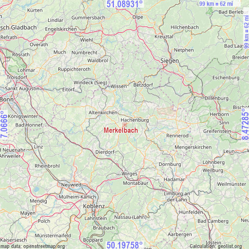
Merkelbach GPS coordinates[2]
50° 38' 44.016" North, 7° 46' 10.992" East
| Map corner | latitude | longitude |
|---|---|---|
| Upper-left | 51.08931°, | 7.0666° |
| Center: | 50.64556°, | 7.76972° |
| Lower-right: | 50.19758°, | 8.47285° |
| Map W x H: | 99.2×99.1 km | = 61.6×61.6mi |
| max Lat: | 55.01917° ⇑49.4% North |
| Merkelbach: | 50.64556° |
| min Lat: | ⇓50.6% South 47.40724° |
| min Long | Merkelbach | max Long |
| 5.92978° | 7.76972° | 14.98853° |
| W 18.4%⇐ | ⇒81.6% E |
Elevation
Elevation of Merkelbach is 343 m = 1125 ft, and this is 93.9 m = 308 ft above average elevation for this country.
| Max E: |
1256 m = 4121 ft | 31.9% |
| Merkelbach | 343 m 1125 ft | |
| Avg. | 249.1 m = 817 ft | |
Min E: |
-5 m = -16 ft | 68.1% |
See also: Germany elevation on elevation.city.
Geographical zone
Merkelbach is located in North temperate zone (between Tropic of Cancer and the Arctic Circle). Distance of this North polar circle is 1769.9 km =1099.8 mi to North.| Distance of | km | miles | from Merkelbach |
|---|---|---|---|
| North Pole | 4375.8 | 2719 | to North |
| Arctic Circle | 1769.9 | 1099.8 | to North |
| Tropic Cancer | 3025.3 | 1879.8 | to South |
| Equator | 5631.3 | 3499.1 | to South |


Nearby cities:
15 places around Merkelbach: (largest is in red/bold)
• Berod bei Höchstenbach
5.4 km =3.4 mi,  272°
272°
• Borod
4.9 km =3 mi,  299°
299°
• Gehlert
4.2 km =2.6 mi,  95°
95°
• Hachenburg
4.1 km =2.5 mi,  66°
66°
• Hattert
2.4 km =1.5 mi,  354°
354°
• Höchstenbach
2.2 km =1.4 mi,  232°
232°
• Marzhausen
5.2 km =3.2 mi, 349°
• Mudenbach
3.5 km =2.2 mi,  312°
312°
• Mündersbach
5 km =3.1 mi,  209°
209°
• Müschenbach
4.3 km =2.7 mi,  12°
12°
• Steinebach
4.7 km =2.9 mi,  147°
147°
• Wahlrod
3.8 km =2.4 mi,  277°
277°
• Welkenbach
3.3 km =2.1 mi,  246°
246°
• Wied
1.1 km =0.7 mi, 231°
• Winkelbach
2.6 km =1.6 mi, 280°
Sources, notices
• [Note1] Compared only with cities in Germany existing in our database
• [Src1] Map data: © OpenStreetMap contributors (CC-BY-SA)
• [Src2] Other city data from geonames.org with taken over terms of usage.
• [Src3] Geographical zone / Annual Mean Temperature by Robert A. Rohde @ Wikipedia
