Gahlenz geodata
Gahlenz (Saxony) is a populated place; located in Germany in Europe/Berlin (GMT+2) time zone. With population of 919 people, there are 7458 cities with bigger population in this country. Compared to other cities in Germany, 54.7% of cities are located further ↓South; 93.7% of cities are located further ←West and 78.7% of cities have lower elevation than Gahlenz. Note1


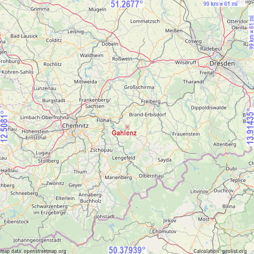
Gahlenz GPS coordinates[2]
50° 49' 32.376" North, 13° 12' 40.392" East
| Map corner | latitude | longitude |
|---|---|---|
| Upper-left | 51.2677°, | 12.5081° |
| Center: | 50.82566°, | 13.21122° |
| Lower-right: | 50.37939°, | 13.91435° |
| Map W x H: | 98.8×98.8 km | = 61.4×61.4mi |
| max Lat: | 55.01917° ⇑45.3% North |
| Gahlenz: | 50.82566° |
| min Lat: | ⇓54.7% South 47.40724° |
| min Long | Gahlenz | max Long |
| 5.92978° | 13.21122° | 14.98853° |
| W 93.7%⇐ | ⇒6.3% E |
Elevation
Elevation of Gahlenz is 424 m = 1391 ft, and this is 174.9 m = 574 ft above average elevation for this country.
| Max E: |
1256 m = 4121 ft | 21.3% |
| Gahlenz | 424 m 1391 ft | |
| Avg. | 249.1 m = 817 ft | |
Min E: |
-5 m = -16 ft | 78.7% |
See also: Germany elevation on elevation.city.
Geographical zone
Gahlenz is located in North temperate zone (between Tropic of Cancer and the Arctic Circle). Distance of this North polar circle is 1749.9 km =1087.3 mi to North.| Distance of | km | miles | from Gahlenz |
|---|---|---|---|
| North Pole | 4355.8 | 2706.6 | to North |
| Arctic Circle | 1749.9 | 1087.3 | to North |
| Tropic Cancer | 3045.4 | 1892.3 | to South |
| Equator | 5651.3 | 3511.6 | to South |


Nearby cities:
15 places around Gahlenz: (largest is in red/bold)
• Augustusburg
7.8 km =4.8 mi,  258°
258°
• Borstendorf
6.2 km =3.9 mi,  201°
201°
• Brand-Erbisdorf
9.1 km =5.7 mi,  59°
59°
• Börnichen
9.8 km =6.1 mi,  210°
210°
• Eppendorf
3.2 km =2 mi,  151°
151°
• Falkenau
7.4 km =4.6 mi,  296°
296°
• Flöha
10.2 km =6.3 mi,  289°
289°
• Frankenstein
8.3 km =5.2 mi,  359°
359°
• Großhartmannsdorf
9 km =5.6 mi,  108°
108°
• Grünhainichen
7.7 km =4.8 mi, 211°
• Lengefeld
11.9 km =7.4 mi,  186°
186°
• Leubsdorf
4.2 km =2.6 mi,  227°
227°
• Oberschöna
8.5 km =5.3 mi,  20°
20°
• Oederan
4.8 km =3 mi,  324°
324°
• Zschopau
12.8 km =8 mi, 227°
Sources, notices
• [Note1] Compared only with cities in Germany existing in our database
• [Src1] Map data: © OpenStreetMap contributors (CC-BY-SA)
• [Src2] Other city data from geonames.org with taken over terms of usage.
• [Src3] Geographical zone / Annual Mean Temperature by Robert A. Rohde @ Wikipedia
