Frankenstein geodata
Frankenstein (Saxony) is a populated place; located in Germany in Europe/Berlin (GMT+2) time zone. With population of 1,226 people, there are 6500 cities with bigger population in this country. Compared to other cities in Germany, 56.1% of cities are located further ↓South; 93.7% of cities are located further ←West and 72.2% of cities have lower elevation than Frankenstein. Note1


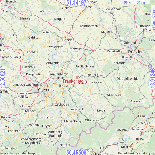
Frankenstein GPS coordinates[2]
50° 54' 2.304" North, 13° 12' 33.588" East
| Map corner | latitude | longitude |
|---|---|---|
| Upper-left | 51.34197°, | 12.50621° |
| Center: | 50.90064°, | 13.20933° |
| Lower-right: | 50.45509°, | 13.91246° |
| Map W x H: | 98.6×98.6 km | = 61.3×61.3mi |
| max Lat: | 55.01917° ⇑43.9% North |
| Frankenstein: | 50.90064° |
| min Lat: | ⇓56.1% South 47.40724° |
| min Long | Frankenstein | max Long |
| 5.92978° | 13.20933° | 14.98853° |
| W 93.7%⇐ | ⇒6.3% E |
Elevation
Elevation of Frankenstein is 375 m = 1230 ft, and this is 125.9 m = 413 ft above average elevation for this country.
| Max E: |
1256 m = 4121 ft | 27.8% |
| Frankenstein | 375 m 1230 ft | |
| Avg. | 249.1 m = 817 ft | |
Min E: |
-5 m = -16 ft | 72.2% |
See also: Germany elevation on elevation.city.
Geographical zone
Frankenstein is located in North temperate zone (between Tropic of Cancer and the Arctic Circle). Distance of this North polar circle is 1741.6 km =1082.2 mi to North.| Distance of | km | miles | from Frankenstein |
|---|---|---|---|
| North Pole | 4347.4 | 2701.3 | to North |
| Arctic Circle | 1741.6 | 1082.2 | to North |
| Tropic Cancer | 3053.7 | 1897.5 | to South |
| Equator | 5659.6 | 3516.7 | to South |


Nearby cities:
15 places around Frankenstein: (largest is in red/bold)
• Augustusburg
12.4 km =7.7 mi,  217°
217°
• Brand-Erbisdorf
8.8 km =5.5 mi,  115°
115°
• Eppendorf
11.3 km =7 mi,  171°
171°
• Falkenau
8.2 km =5.1 mi,  232°
232°
• Flöha
10.7 km =6.6 mi,  242°
242°
• Frankenberg
11.9 km =7.4 mi,  276°
276°
• Freiberg
9.1 km =5.7 mi,  82°
82°
• Gahlenz
8.3 km =5.2 mi,  179°
179°
• Großschirma
9 km =5.6 mi,  36°
36°
• Hainichen
9.8 km =6.1 mi,  322°
322°
• Halsbrücke
11.3 km =7 mi,  60°
60°
• Leubsdorf
11.6 km =7.2 mi,  194°
194°
• Niederwiesa
14 km =8.7 mi,  254°
254°
• Oberschöna
3.1 km =1.9 mi,  96°
96°
• Oederan
5.2 km =3.2 mi,  210°
210°
Sources, notices
• [Note1] Compared only with cities in Germany existing in our database
• [Src1] Map data: © OpenStreetMap contributors (CC-BY-SA)
• [Src2] Other city data from geonames.org with taken over terms of usage.
• [Src3] Geographical zone / Annual Mean Temperature by Robert A. Rohde @ Wikipedia
