Vilshofen geodata
Vilshofen (Bavaria) is a populated place; located in Germany in Europe/Berlin (GMT+2) time zone. With population of 16,695 people, there are 946 cities with bigger population in this country. Compared to other cities in Germany, 87.4% of cities are located further ↑North; 93.6% of cities are located further ←West and 64.7% of cities have lower elevation than Vilshofen. Note1
Administrative division(s):
- Level 1: Bavaria
- Level 2: Lower Bavaria
- Level 3: Landkreis Passau
- Level 4: Vilshofen an der Donau


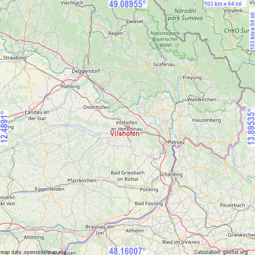
Vilshofen GPS coordinates[2]
48° 37' 37.02" North, 13° 11' 31.992" East
| Map corner | latitude | longitude |
|---|---|---|
| Upper-left | 49.08955°, | 12.4891° |
| Center: | 48.62695°, | 13.19222° |
| Lower-right: | 48.16007°, | 13.89535° |
| Map W x H: | 103.3×103.3 km | = 64.2×64.2mi |
| max Lat: | 55.01917° ⇑87.4% North |
| Vilshofen: | 48.62695° |
| min Lat: | ⇓12.6% South 47.40724° |
| min Long | Vilshofen | max Long |
| 5.92978° | 13.19222° | 14.98853° |
| W 93.6%⇐ | ⇒6.4% E |
Elevation
Elevation of Vilshofen is 319 m = 1047 ft, and this is 69.9 m = 229 ft above average elevation for this country.
| Max E: |
1256 m = 4121 ft | 35.3% |
| Vilshofen | 319 m 1047 ft | |
| Avg. | 249.1 m = 817 ft | |
Min E: |
-5 m = -16 ft | 64.7% |
See also: Germany elevation on elevation.city.
Geographical zone
Vilshofen is located in North temperate zone (between Tropic of Cancer and the Arctic Circle). Distance of this North polar circle is 1994.4 km =1239.3 mi to North.| Distance of | km | miles | from Vilshofen |
|---|---|---|---|
| North Pole | 4600.3 | 2858.5 | to North |
| Arctic Circle | 1994.4 | 1239.3 | to North |
| Tropic Cancer | 2800.9 | 1740.4 | to South |
| Equator | 5406.8 | 3359.6 | to South |


Nearby cities:
15 places around Vilshofen: (largest is in red/bold)
• Aicha vorm Wald
9.3 km =5.8 mi,  54°
54°
• Aidenbach
9.8 km =6.1 mi,  230°
230°
• Aldersbach
8.6 km =5.3 mi,  241°
241°
• Außernzell
10.8 km =6.7 mi,  4°
4°
• Beutelsbach
10.2 km =6.3 mi,  213°
213°
• Fürstenstein
14.4 km =8.9 mi, 46°
• Haarbach
14.5 km =9 mi,  192°
192°
• Haselbach
14.6 km =9.1 mi,  81°
81°
• Hofkirchen
7.8 km =4.8 mi,  316°
316°
• Iggensbach
12 km =7.5 mi,  342°
342°
• Künzing
9.1 km =5.7 mi,  298°
298°
• Ortenburg
9.3 km =5.8 mi,  166°
166°
• Reut
6.4 km =4 mi, 232°
• Schöllnach
14.2 km =8.8 mi,  355°
355°
• Winzer
13.6 km =8.5 mi, 321°
Sources, notices
• [Note1] Compared only with cities in Germany existing in our database
• [Src1] Map data: © OpenStreetMap contributors (CC-BY-SA)
• [Src2] Other city data from geonames.org with taken over terms of usage.
• [Src3] Geographical zone / Annual Mean Temperature by Robert A. Rohde @ Wikipedia
