Neuhaus am Inn geodata
Neuhaus am Inn (Bavaria) is a seat of a fourth-order administrative division; located in Germany in Europe/Berlin (GMT+2) time zone. With population of 3,398 people, there are 3689 cities with bigger population in this country. Compared to other cities in Germany, 89.6% of cities are located further ↑North; 95.3% of cities are located further ←West and 65% of cities have lower elevation than Neuhaus am Inn. Note1
Administrative division(s):
- Level 1: Bavaria
- Level 2: Lower Bavaria
- Level 3: Landkreis Passau
- Level 4: Neuhaus a.Inn


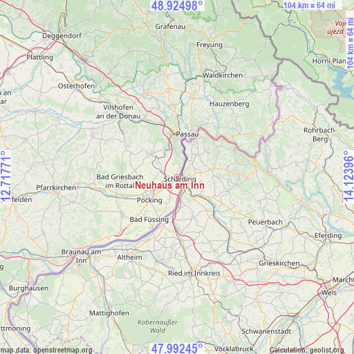
Neuhaus am Inn GPS coordinates[2]
48° 27' 39.096" North, 13° 25' 14.988" East
| Map corner | latitude | longitude |
|---|---|---|
| Upper-left | 48.92498°, | 12.71771° |
| Center: | 48.46086°, | 13.42083° |
| Lower-right: | 47.99245°, | 14.12396° |
| Map W x H: | 103.7×103.7 km | = 64.4×64.4mi |
| max Lat: | 55.01917° ⇑89.6% North |
| Neuhaus am Inn: | 48.46086° |
| min Lat: | ⇓10.4% South 47.40724° |
| min Long | Neuhaus am Inn | max Long |
| 5.92978° | 13.42083° | 14.98853° |
| W 95.3%⇐ | ⇒4.7% E |
Elevation
Elevation of Neuhaus am Inn is 321 m = 1053 ft, and this is 71.9 m = 236 ft above average elevation for this country.
| Max E: |
1256 m = 4121 ft | 35% |
| Neuhaus am Inn | 321 m 1053 ft | |
| Avg. | 249.1 m = 817 ft | |
Min E: |
-5 m = -16 ft | 65% |
See also: Germany elevation on elevation.city.
Geographical zone
Neuhaus am Inn is located in North temperate zone (between Tropic of Cancer and the Arctic Circle). Distance of this North polar circle is 2012.8 km =1250.7 mi to North.| Distance of | km | miles | from Neuhaus am Inn |
|---|---|---|---|
| North Pole | 4618.7 | 2869.9 | to North |
| Arctic Circle | 2012.8 | 1250.7 | to North |
| Tropic Cancer | 2782.4 | 1728.9 | to South |
| Equator | 5388.3 | 3348.1 | to South |


Nearby cities:
15 places around Neuhaus am Inn: (largest is in red/bold)
• Bad Füssing
14.6 km =9.1 mi,  213°
213°
• Bad Griesbach
16.8 km =10.4 mi,  266°
266°
• Fürstenzell
10.2 km =6.3 mi,  311°
311°
• Kirchham
17 km =10.6 mi,  221°
221°
• Neuburg
5.4 km =3.4 mi,  20°
20°
• Obernzell
19.1 km =11.9 mi,  56°
56°
• Ortenburg
17.4 km =10.8 mi,  302°
302°
• Passau
11.8 km =7.3 mi,  3°
3°
• Pocking
10.3 km =6.4 mi,  230°
230°
• Rotthalmünster
19.8 km =12.3 mi, 234°
• Salzweg
17.9 km =11.1 mi,  14°
14°
• Tettenweis
11.3 km =7 mi,  259°
259°
• Thyrnau
19.2 km =11.9 mi,  25°
25°
• Tiefenbach
18.2 km =11.3 mi,  355°
355°
• Witzmannsberg
18.7 km =11.6 mi, 16°
Sources, notices
• [Note1] Compared only with cities in Germany existing in our database
• [Src1] Map data: © OpenStreetMap contributors (CC-BY-SA)
• [Src2] Other city data from geonames.org with taken over terms of usage.
• [Src3] Geographical zone / Annual Mean Temperature by Robert A. Rohde @ Wikipedia
