Ortenburg geodata
Ortenburg (Bavaria) is a populated place; located in Germany in Europe/Berlin (GMT+2) time zone. With population of 7,317 people, there are 2112 cities with bigger population in this country. Compared to other cities in Germany, 88.5% of cities are located further ↑North; 93.8% of cities are located further ←West and 68.6% of cities have lower elevation than Ortenburg. Note1
Administrative division(s):
- Level 1: Bavaria
- Level 2: Lower Bavaria
- Level 3: Landkreis Passau
- Level 4: Ortenburg, Markt


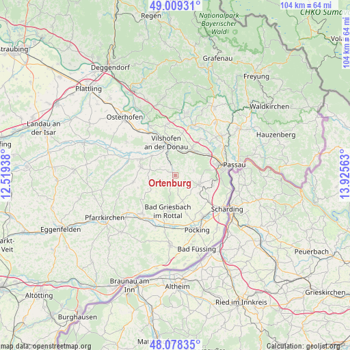
Ortenburg GPS coordinates[2]
48° 32' 45.492" North, 13° 13' 21" East
| Map corner | latitude | longitude |
|---|---|---|
| Upper-left | 49.00931°, | 12.51938° |
| Center: | 48.54597°, | 13.2225° |
| Lower-right: | 48.07835°, | 13.92563° |
| Map W x H: | 103.5×103.5 km | = 64.3×64.3mi |
| max Lat: | 55.01917° ⇑88.5% North |
| Ortenburg: | 48.54597° |
| min Lat: | ⇓11.5% South 47.40724° |
| min Long | Ortenburg | max Long |
| 5.92978° | 13.2225° | 14.98853° |
| W 93.8%⇐ | ⇒6.2% E |
Elevation
Elevation of Ortenburg is 347 m = 1138 ft, and this is 97.9 m = 321 ft above average elevation for this country.
| Max E: |
1256 m = 4121 ft | 31.4% |
| Ortenburg | 347 m 1138 ft | |
| Avg. | 249.1 m = 817 ft | |
Min E: |
-5 m = -16 ft | 68.6% |
See also: Germany elevation on elevation.city.
Geographical zone
Ortenburg is located in North temperate zone (between Tropic of Cancer and the Arctic Circle). Distance of this North polar circle is 2003.4 km =1244.9 mi to North.| Distance of | km | miles | from Ortenburg |
|---|---|---|---|
| North Pole | 4609.3 | 2864.1 | to North |
| Arctic Circle | 2003.4 | 1244.9 | to North |
| Tropic Cancer | 2791.9 | 1734.8 | to South |
| Equator | 5397.8 | 3354 | to South |


Nearby cities:
15 places around Ortenburg: (largest is in red/bold)
• Aicha vorm Wald
15.4 km =9.6 mi,  20°
20°
• Aidenbach
10.1 km =6.3 mi,  285°
285°
• Aldersbach
10.9 km =6.8 mi,  296°
296°
• Bad Birnbach
14.8 km =9.2 mi,  220°
220°
• Bad Griesbach
10.7 km =6.6 mi,  191°
191°
• Bayerbach
16.2 km =10.1 mi,  200°
200°
• Beutelsbach
7.8 km =4.8 mi,  273°
273°
• Egglham
12.5 km =7.8 mi,  261°
261°
• Fürstenzell
7.5 km =4.7 mi,  111°
111°
• Haarbach
7.4 km =4.6 mi,  226°
226°
• Passau
15.5 km =9.6 mi,  81°
81°
• Reut
8.9 km =5.5 mi, 304°
• Tettenweis
12 km =7.5 mi,  163°
163°
• Tiefenbach
15.7 km =9.8 mi,  56°
56°
• Vilshofen
9.3 km =5.8 mi,  346°
346°
Sources, notices
• [Note1] Compared only with cities in Germany existing in our database
• [Src1] Map data: © OpenStreetMap contributors (CC-BY-SA)
• [Src2] Other city data from geonames.org with taken over terms of usage.
• [Src3] Geographical zone / Annual Mean Temperature by Robert A. Rohde @ Wikipedia
