Fürstenberg geodata
Fürstenberg (Baden-Württemberg) is a populated place; located in Germany in Europe/Berlin (GMT+2) time zone. With population of 2,278 people, there are 4706 cities with bigger population in this country. Compared to other cities in Germany, 99% of cities are located further ↑North; 63.1% of cities are located further →East and 75.9% of cities have lower elevation than Fürstenberg. Note1
Administrative division(s):
- Level 1: Baden-Württemberg
- Level 2: Freiburg Region
- Level 3: Landkreis Konstanz
- Level 4: Konstanz, Universitätsstadt


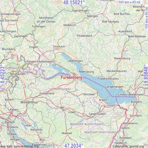
Fürstenberg GPS coordinates[2]
47° 40' 44.22" North, 9° 9' 19.26" East
| Map corner | latitude | longitude |
|---|---|---|
| Upper-left | 48.15021°, | 8.45223° |
| Center: | 47.67895°, | 9.15535° |
| Lower-right: | 47.2034°, | 9.85848° |
| Map W x H: | 105.3×105.3 km | = 65.4×65.4mi |
| max Lat: | 55.01917° ⇑99% North |
| Fürstenberg: | 47.67895° |
| min Lat: | ⇓1% South 47.40724° |
| min Long | Fürstenberg | max Long |
| 5.92978° | 9.15535° | 14.98853° |
| W 36.9%⇐ | ⇒63.1% E |
Elevation
Elevation of Fürstenberg is 405 m = 1329 ft, and this is 155.9 m = 511 ft above average elevation for this country.
| Max E: |
1256 m = 4121 ft | 24.1% |
| Fürstenberg | 405 m 1329 ft | |
| Avg. | 249.1 m = 817 ft | |
Min E: |
-5 m = -16 ft | 75.9% |
See also: Germany elevation on elevation.city.
Geographical zone
Fürstenberg is located in North temperate zone (between Tropic of Cancer and the Arctic Circle). Distance of this North polar circle is 2099.8 km =1304.8 mi to North.| Distance of | km | miles | from Fürstenberg |
|---|---|---|---|
| North Pole | 4705.7 | 2924 | to North |
| Arctic Circle | 2099.8 | 1304.8 | to North |
| Tropic Cancer | 2695.5 | 1674.9 | to South |
| Equator | 5301.4 | 3294.1 | to South |


Nearby cities:
15 places around Fürstenberg: (largest is in red/bold)
• Allensbach
7.5 km =4.7 mi,  302°
302°
• Bermatingen
15.8 km =9.8 mi,  67°
67°
• Daisendorf
9.2 km =5.7 mi, 66°
• Gaienhofen
12.9 km =8 mi,  272°
272°
• Hagnau
12.2 km =7.6 mi,  91°
91°
• Konstanz
2.6 km =1.6 mi,  143°
143°
• Meersburg
8.8 km =5.5 mi,  78°
78°
• Owingen
14.6 km =9.1 mi,  4°
4°
• Radolfzell
15.5 km =9.6 mi, 296°
• Reichenau
7 km =4.3 mi,  279°
279°
• Salem
13.7 km =8.5 mi,  47°
47°
• Sipplingen
13.8 km =8.6 mi,  341°
341°
• Stetten
10.8 km =6.7 mi, 83°
• Uhldingen-Mühlhofen
9.3 km =5.8 mi, 49°
• Überlingen
10.2 km =6.3 mi,  6°
6°
Sources, notices
• [Note1] Compared only with cities in Germany existing in our database
• [Src1] Map data: © OpenStreetMap contributors (CC-BY-SA)
• [Src2] Other city data from geonames.org with taken over terms of usage.
• [Src3] Geographical zone / Annual Mean Temperature by Robert A. Rohde @ Wikipedia
