Uhldingen-Mühlhofen geodata
Uhldingen-Mühlhofen (Baden-Württemberg) is a seat of a fourth-order administrative division; located in Germany in Europe/Berlin (GMT+2) time zone. With population of 8,013 people, there are 1953 cities with bigger population in this country. Compared to other cities in Germany, 98.5% of cities are located further ↑North; 61.5% of cities are located further →East and 77.9% of cities have lower elevation than Uhldingen-Mühlhofen. Note1
Administrative division(s):
- Level 1: Baden-Württemberg
- Level 2: Tübingen Region
- Level 3: Bodenseekreis
- Level 4: Uhldingen-Mühlhofen


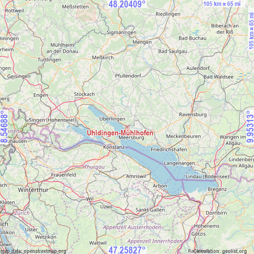
Uhldingen-Mühlhofen GPS coordinates[2]
47° 43' 59.988" North, 9° 15' 0" East
| Map corner | latitude | longitude |
|---|---|---|
| Upper-left | 48.20409°, | 8.54688° |
| Center: | 47.73333°, | 9.25° |
| Lower-right: | 47.25827°, | 9.95313° |
| Map W x H: | 105.2×105.2 km | = 65.4×65.4mi |
| max Lat: | 55.01917° ⇑98.5% North |
| Uhldingen-Mühlhofen: | 47.73333° |
| min Lat: | ⇓1.5% South 47.40724° |
| min Long | Uhldingen-Mühl | max Long |
| 5.92978° | 9.25° | 14.98853° |
| W 38.5%⇐ | ⇒61.5% E |
Elevation
Elevation of Uhldingen-Mühlhofen is 418 m = 1371 ft, and this is 168.9 m = 554 ft above average elevation for this country.
| Max E: |
1256 m = 4121 ft | 22.1% |
| Uhldingen-Mühlhofen | 418 m 1371 ft | |
| Avg. | 249.1 m = 817 ft | |
Min E: |
-5 m = -16 ft | 77.9% |
See also: Germany elevation on elevation.city.
Geographical zone
Uhldingen-Mühlhofen is located in North temperate zone (between Tropic of Cancer and the Arctic Circle). Distance of this North polar circle is 2093.7 km =1301 mi to North.| Distance of | km | miles | from Uhldingen-Mühlhofen |
|---|---|---|---|
| North Pole | 4699.6 | 2920.2 | to North |
| Arctic Circle | 2093.7 | 1301 | to North |
| Tropic Cancer | 2701.5 | 1678.6 | to South |
| Equator | 5307.4 | 3297.9 | to South |


Nearby cities:
15 places around Uhldingen-Mühlhofen: (largest is in red/bold)
• Bermatingen
7.5 km =4.7 mi,  90°
90°
• Daisendorf
2.7 km =1.7 mi,  149°
149°
• Frickingen
9.2 km =5.7 mi,  11°
11°
• Fürstenberg
9.3 km =5.8 mi,  229°
229°
• Hagnau
8.1 km =5 mi,  141°
141°
• Heiligenberg
10.8 km =6.7 mi,  25°
25°
• Immenstaad am Bodensee
11.5 km =7.1 mi,  130°
130°
• Konstanz
9.8 km =6.1 mi,  214°
214°
• Markdorf
10.6 km =6.6 mi,  98°
98°
• Meersburg
4.6 km =2.9 mi,  160°
160°
• Owingen
10.3 km =6.4 mi,  325°
325°
• Salem
4.4 km =2.7 mi,  42°
42°
• Sipplingen
13.4 km =8.3 mi,  301°
301°
• Stetten
6 km =3.7 mi, 142°
• Überlingen
7.1 km =4.4 mi, 304°
In other languages:
- In Spanish: Unteruhldigen
- In Russian: Ульдинген-Мюльхофен
- In Chinese: 乌尔丁根-米赫尔霍芬
Sources, notices
• [Note1] Compared only with cities in Germany existing in our database
• [Src1] Map data: © OpenStreetMap contributors (CC-BY-SA)
• [Src2] Other city data from geonames.org with taken over terms of usage.
• [Src3] Geographical zone / Annual Mean Temperature by Robert A. Rohde @ Wikipedia
