Stetten geodata
Stetten (Baden-Württemberg) is a seat of a fourth-order administrative division; located in Germany in Europe/Berlin (GMT+2) time zone. With population of 953 people, there are 7337 cities with bigger population in this country. Compared to other cities in Germany, 98.9% of cities are located further ↑North; 60.8% of cities are located further →East and 83.9% of cities have lower elevation than Stetten. Note1
Administrative division(s):
- Level 1: Baden-Württemberg
- Level 2: Tübingen Region
- Level 3: Bodenseekreis
- Level 4: Stetten


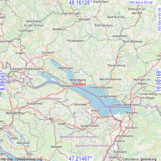
Stetten GPS coordinates[2]
47° 41' 24.432" North, 9° 17' 54.78" East
| Map corner | latitude | longitude |
|---|---|---|
| Upper-left | 48.16128°, | 8.59543° |
| Center: | 47.69012°, | 9.29855° |
| Lower-right: | 47.21467°, | 10.00168° |
| Map W x H: | 105.3×105.3 km | = 65.4×65.4mi |
| max Lat: | 55.01917° ⇑98.9% North |
| Stetten: | 47.69012° |
| min Lat: | ⇓1.1% South 47.40724° |
| min Long | Stetten | max Long |
| 5.92978° | 9.29855° | 14.98853° |
| W 39.2%⇐ | ⇒60.8% E |
Elevation
Elevation of Stetten is 461 m = 1512 ft, and this is 211.9 m = 695 ft above average elevation for this country.
| Max E: |
1256 m = 4121 ft | 16.1% |
| Stetten | 461 m 1512 ft | |
| Avg. | 249.1 m = 817 ft | |
Min E: |
-5 m = -16 ft | 83.9% |
See also: Germany elevation on elevation.city.
Geographical zone
Stetten is located in North temperate zone (between Tropic of Cancer and the Arctic Circle). Distance of this North polar circle is 2098.5 km =1303.9 mi to North.| Distance of | km | miles | from Stetten |
|---|---|---|---|
| North Pole | 4704.4 | 2923.2 | to North |
| Arctic Circle | 2098.5 | 1303.9 | to North |
| Tropic Cancer | 2696.7 | 1675.7 | to South |
| Equator | 5302.6 | 3294.9 | to South |


Nearby cities:
15 places around Stetten: (largest is in red/bold)
• Bermatingen
6.2 km =3.9 mi,  38°
38°
• Daisendorf
3.4 km =2.1 mi,  317°
317°
• Frickingen
13.9 km =8.6 mi,  352°
352°
• Friedrichshafen
13.8 km =8.6 mi,  105°
105°
• Fürstenberg
10.8 km =6.7 mi,  263°
263°
• Hagnau
2.1 km =1.3 mi,  135°
135°
• Heiligenberg
14.6 km =9.1 mi,  4°
4°
• Immenstaad am Bodensee
5.7 km =3.5 mi,  117°
117°
• Konstanz
9.8 km =6.1 mi,  250°
250°
• Markdorf
7.6 km =4.7 mi,  64°
64°
• Meersburg
2.1 km =1.3 mi,  282°
282°
• Oberteuringen
13.4 km =8.3 mi,  73°
73°
• Salem
8.1 km =5 mi,  355°
355°
• Uhldingen-Mühlhofen
6 km =3.7 mi, 322°
• Überlingen
13 km =8.1 mi,  312°
312°
Sources, notices
• [Note1] Compared only with cities in Germany existing in our database
• [Src1] Map data: © OpenStreetMap contributors (CC-BY-SA)
• [Src2] Other city data from geonames.org with taken over terms of usage.
• [Src3] Geographical zone / Annual Mean Temperature by Robert A. Rohde @ Wikipedia
