Hagnau geodata
Hagnau (Baden-Württemberg) is a populated place; located in Germany in Europe/Berlin (GMT+2) time zone. With population of 1,342 people, there are 6198 cities with bigger population in this country. Compared to other cities in Germany, 99% of cities are located further ↑North; 60.5% of cities are located further →East and 77.6% of cities have lower elevation than Hagnau. Note1
Administrative division(s):
- Level 1: Baden-Württemberg
- Level 2: Tübingen Region
- Level 3: Bodenseekreis
- Level 4: Hagnau am Bodensee


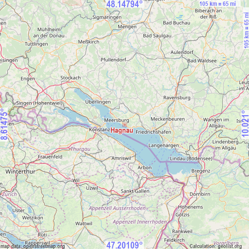
Hagnau GPS coordinates[2]
47° 40' 35.976" North, 9° 19' 4.332" East
| Map corner | latitude | longitude |
|---|---|---|
| Upper-left | 48.14794°, | 8.61475° |
| Center: | 47.67666°, | 9.31787° |
| Lower-right: | 47.20109°, | 10.021° |
| Map W x H: | 105.3×105.3 km | = 65.4×65.4mi |
| max Lat: | 55.01917° ⇑99% North |
| Hagnau: | 47.67666° |
| min Lat: | ⇓1% South 47.40724° |
| min Long | Hagnau | max Long |
| 5.92978° | 9.31787° | 14.98853° |
| W 39.5%⇐ | ⇒60.5% E |
Elevation
Elevation of Hagnau is 416 m = 1365 ft, and this is 166.9 m = 548 ft above average elevation for this country.
| Max E: |
1256 m = 4121 ft | 22.4% |
| Hagnau | 416 m 1365 ft | |
| Avg. | 249.1 m = 817 ft | |
Min E: |
-5 m = -16 ft | 77.6% |
See also: Germany elevation on elevation.city.
Geographical zone
Hagnau is located in North temperate zone (between Tropic of Cancer and the Arctic Circle). Distance of this North polar circle is 2100 km =1304.9 mi to North.| Distance of | km | miles | from Hagnau |
|---|---|---|---|
| North Pole | 4705.9 | 2924.1 | to North |
| Arctic Circle | 2100 | 1304.9 | to North |
| Tropic Cancer | 2695.2 | 1674.7 | to South |
| Equator | 5301.1 | 3293.9 | to South |


Nearby cities:
15 places around Hagnau: (largest is in red/bold)
• Bermatingen
6.7 km =4.2 mi,  20°
20°
• Daisendorf
5.5 km =3.4 mi,  316°
316°
• Frickingen
15.7 km =9.8 mi,  347°
347°
• Friedrichshafen
12 km =7.5 mi,  100°
100°
• Fürstenberg
12.2 km =7.6 mi,  271°
271°
• Heiligenberg
16 km =9.9 mi,  358°
358°
• Immenstaad am Bodensee
3.8 km =2.4 mi,  106°
106°
• Konstanz
10.8 km =6.7 mi,  260°
260°
• Markdorf
7.2 km =4.5 mi,  48°
48°
• Meersburg
4 km =2.5 mi,  299°
299°
• Oberteuringen
12.5 km =7.8 mi,  65°
65°
• Salem
9.8 km =6.1 mi, 347°
• Stetten
2.1 km =1.3 mi, 315°
• Uhldingen-Mühlhofen
8.1 km =5 mi, 321°
• Überlingen
15.1 km =9.4 mi,  313°
313°
Sources, notices
• [Note1] Compared only with cities in Germany existing in our database
• [Src1] Map data: © OpenStreetMap contributors (CC-BY-SA)
• [Src2] Other city data from geonames.org with taken over terms of usage.
• [Src3] Geographical zone / Annual Mean Temperature by Robert A. Rohde @ Wikipedia
