Freudenstadt geodata
Freudenstadt (Baden-Württemberg) is a seat of a third-order administrative division; located in Germany in Europe/Berlin (GMT+2) time zone. With population of 23,868 people, there are 628 cities with bigger population in this country. Compared to other cities in Germany, 89.4% of cities are located further ↑North; 71.8% of cities are located further →East and 98.5% of cities have lower elevation than Freudenstadt. Note1
Administrative division(s):
- Level 1: Baden-Württemberg
- Level 2: Karlsruhe Region
- Level 3: Landkreis Freudenstadt
- Level 4: Freudenstadt


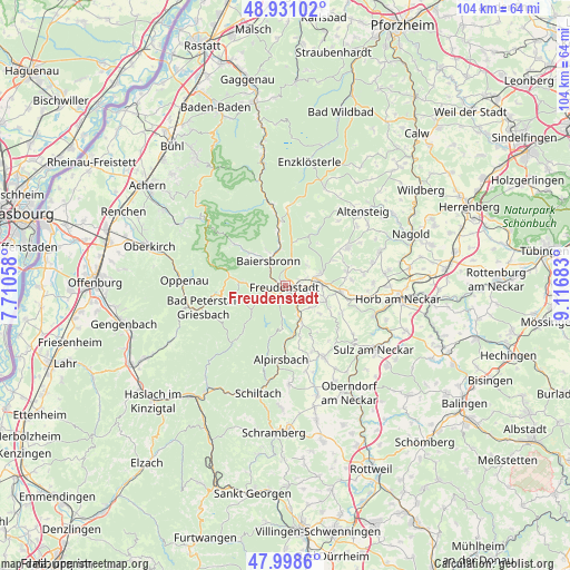
Freudenstadt GPS coordinates[2]
48° 28' 1.02" North, 8° 24' 49.356" East
| Map corner | latitude | longitude |
|---|---|---|
| Upper-left | 48.93102°, | 7.71058° |
| Center: | 48.46695°, | 8.41371° |
| Lower-right: | 47.9986°, | 9.11683° |
| Map W x H: | 103.7×103.7 km | = 64.4×64.4mi |
| max Lat: | 55.01917° ⇑89.4% North |
| Freudenstadt: | 48.46695° |
| min Lat: | ⇓10.6% South 47.40724° |
| min Long | Freudenstadt | max Long |
| 5.92978° | 8.41371° | 14.98853° |
| W 28.2%⇐ | ⇒71.8% E |
Elevation
Elevation of Freudenstadt is 736 m = 2415 ft, and this is 486.9 m = 1597 ft above average elevation for this country.
| Max E: |
1256 m = 4121 ft | 1.5% |
| Freudenstadt | 736 m 2415 ft | |
| Avg. | 249.1 m = 817 ft | |
Min E: |
-5 m = -16 ft | 98.5% |
See also: Germany elevation on elevation.city.
Geographical zone
Freudenstadt is located in North temperate zone (between Tropic of Cancer and the Arctic Circle). Distance of this North polar circle is 2012.2 km =1250.3 mi to North.| Distance of | km | miles | from Freudenstadt |
|---|---|---|---|
| North Pole | 4618 | 2869.5 | to North |
| Arctic Circle | 2012.2 | 1250.3 | to North |
| Tropic Cancer | 2783.1 | 1729.3 | to South |
| Equator | 5389 | 3348.6 | to South |


Nearby cities:
15 places around Freudenstadt: (largest is in red/bold)
• Alpirsbach
13.6 km =8.5 mi,  183°
183°
• Bad Peterstal-Griesbach
15 km =9.3 mi,  255°
255°
• Bad Rippoldsau-Schapbach
7.7 km =4.8 mi,  236°
236°
• Baiersbronn
4.9 km =3 mi,  326°
326°
• Dornhan
14.8 km =9.2 mi,  151°
151°
• Dornstetten
6.3 km =3.9 mi,  84°
84°
• Glatten
7.7 km =4.8 mi,  110°
110°
• Grömbach
15.3 km =9.5 mi,  39°
39°
• Haiterbach
18 km =11.2 mi,  70°
70°
• Loßburg
7.9 km =4.9 mi,  160°
160°
• Pfalzgrafenweiler
13 km =8.1 mi,  59°
59°
• Schenkenzell
17.5 km =10.9 mi,  190°
190°
• Schopfloch
10.2 km =6.3 mi,  97°
97°
• Simmersfeld
18.3 km =11.4 mi,  24°
24°
• Wörnersberg
15.8 km =9.8 mi,  45°
45°
Sources, notices
• [Note1] Compared only with cities in Germany existing in our database
• [Src1] Map data: © OpenStreetMap contributors (CC-BY-SA)
• [Src2] Other city data from geonames.org with taken over terms of usage.
• [Src3] Geographical zone / Annual Mean Temperature by Robert A. Rohde @ Wikipedia
