Schopfloch geodata
Schopfloch (Baden-Württemberg) is a seat of a fourth-order administrative division; located in Germany in Europe/Berlin (GMT+2) time zone. With population of 2,569 people, there are 4361 cities with bigger population in this country. Compared to other cities in Germany, 89.6% of cities are located further ↑North; 70.6% of cities are located further →East and 97.1% of cities have lower elevation than Schopfloch. Note1
Administrative division(s):
- Level 1: Baden-Württemberg
- Level 2: Karlsruhe Region
- Level 3: Landkreis Freudenstadt
- Level 4: Schopfloch


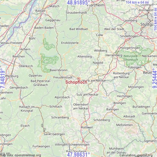
Schopfloch GPS coordinates[2]
48° 27' 17.172" North, 8° 33' 4.716" East
| Map corner | latitude | longitude |
|---|---|---|
| Upper-left | 48.91895°, | 7.84819° |
| Center: | 48.45477°, | 8.55131° |
| Lower-right: | 47.98631°, | 9.25444° |
| Map W x H: | 103.7×103.7 km | = 64.4×64.4mi |
| max Lat: | 55.01917° ⇑89.6% North |
| Schopfloch: | 48.45477° |
| min Lat: | ⇓10.4% South 47.40724° |
| min Long | Schopfloch | max Long |
| 5.92978° | 8.55131° | 14.98853° |
| W 29.4%⇐ | ⇒70.6% E |
Elevation
Elevation of Schopfloch is 666 m = 2185 ft, and this is 416.9 m = 1368 ft above average elevation for this country.
| Max E: |
1256 m = 4121 ft | 2.9% |
| Schopfloch | 666 m 2185 ft | |
| Avg. | 249.1 m = 817 ft | |
Min E: |
-5 m = -16 ft | 97.1% |
See also: Germany elevation on elevation.city.
Geographical zone
Schopfloch is located in North temperate zone (between Tropic of Cancer and the Arctic Circle). Distance of this North polar circle is 2013.5 km =1251.1 mi to North.| Distance of | km | miles | from Schopfloch |
|---|---|---|---|
| North Pole | 4619.4 | 2870.4 | to North |
| Arctic Circle | 2013.5 | 1251.1 | to North |
| Tropic Cancer | 2781.7 | 1728.5 | to South |
| Equator | 5387.7 | 3347.8 | to South |


Nearby cities:
15 places around Schopfloch: (largest is in red/bold)
• Baiersbronn
13.9 km =8.6 mi,  292°
292°
• Dornhan
12.1 km =7.5 mi,  195°
195°
• Dornstetten
4.4 km =2.7 mi,  296°
296°
• Egenhausen
13.3 km =8.3 mi,  21°
21°
• Empfingen
13.6 km =8.5 mi,  120°
120°
• Freudenstadt
10.2 km =6.3 mi,  277°
277°
• Glatten
3.3 km =2.1 mi,  245°
245°
• Grömbach
13.1 km =8.1 mi,  358°
358°
• Haiterbach
10 km =6.2 mi,  43°
43°
• Horb am Neckar
10.4 km =6.5 mi,  96°
96°
• Loßburg
9.6 km =6 mi,  230°
230°
• Mühlheim am Bach
13.7 km =8.5 mi,  128°
128°
• Pfalzgrafenweiler
8 km =5 mi,  7°
7°
• Sulz am Neckar
11.9 km =7.4 mi,  149°
149°
• Wörnersberg
12.5 km =7.8 mi, 5°
Sources, notices
• [Note1] Compared only with cities in Germany existing in our database
• [Src1] Map data: © OpenStreetMap contributors (CC-BY-SA)
• [Src2] Other city data from geonames.org with taken over terms of usage.
• [Src3] Geographical zone / Annual Mean Temperature by Robert A. Rohde @ Wikipedia
