Baiersbronn geodata
Baiersbronn (Baden-Württemberg) is a seat of a fourth-order administrative division; located in Germany in Europe/Berlin (GMT+2) time zone. With population of 16,248 people, there are 976 cities with bigger population in this country. Compared to other cities in Germany, 89.1% of cities are located further ↑North; 72.1% of cities are located further →East and 94.9% of cities have lower elevation than Baiersbronn. Note1
Administrative division(s):
- Level 1: Baden-Württemberg
- Level 2: Karlsruhe Region
- Level 3: Landkreis Freudenstadt
- Level 4: Baiersbronn


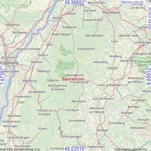
Baiersbronn GPS coordinates[2]
48° 30' 11.448" North, 8° 22' 37.164" East
| Map corner | latitude | longitude |
|---|---|---|
| Upper-left | 48.96692°, | 7.67387° |
| Center: | 48.50318°, | 8.37699° |
| Lower-right: | 48.03516°, | 9.08012° |
| Map W x H: | 103.6×103.6 km | = 64.4×64.4mi |
| max Lat: | 55.01917° ⇑89.1% North |
| Baiersbronn: | 48.50318° |
| min Lat: | ⇓10.9% South 47.40724° |
| min Long | Baiersbronn | max Long |
| 5.92978° | 8.37699° | 14.98853° |
| W 27.9%⇐ | ⇒72.1% E |
Elevation
Elevation of Baiersbronn is 598 m = 1962 ft, and this is 348.9 m = 1145 ft above average elevation for this country.
| Max E: |
1256 m = 4121 ft | 5.1% |
| Baiersbronn | 598 m 1962 ft | |
| Avg. | 249.1 m = 817 ft | |
Min E: |
-5 m = -16 ft | 94.9% |
See also: Germany elevation on elevation.city.
Geographical zone
Baiersbronn is located in North temperate zone (between Tropic of Cancer and the Arctic Circle). Distance of this North polar circle is 2008.1 km =1247.8 mi to North.| Distance of | km | miles | from Baiersbronn |
|---|---|---|---|
| North Pole | 4614 | 2867 | to North |
| Arctic Circle | 2008.1 | 1247.8 | to North |
| Tropic Cancer | 2787.1 | 1731.8 | to South |
| Equator | 5393 | 3351.1 | to South |


Nearby cities:
15 places around Baiersbronn: (largest is in red/bold)
• Alpirsbach
17.7 km =11 mi,  174°
174°
• Bad Peterstal-Griesbach
14.1 km =8.8 mi,  236°
236°
• Bad Rippoldsau-Schapbach
9.1 km =5.7 mi,  204°
204°
• Biberach
14 km =8.7 mi,  328°
328°
• Dornstetten
9.6 km =6 mi,  111°
111°
• Freudenstadt
4.9 km =3 mi,  146°
146°
• Glatten
12 km =7.5 mi,  124°
124°
• Grömbach
14.6 km =9.1 mi,  57°
57°
• Loßburg
12.7 km =7.9 mi, 154°
• Oppenau
16.4 km =10.2 mi,  258°
258°
• Pfalzgrafenweiler
14.1 km =8.8 mi,  79°
79°
• Schopfloch
13.9 km =8.6 mi, 112°
• Seebach
17.2 km =10.7 mi,  298°
298°
• Simmersfeld
16.3 km =10.1 mi,  39°
39°
• Wörnersberg
15.6 km =9.7 mi, 63°
Sources, notices
• [Note1] Compared only with cities in Germany existing in our database
• [Src1] Map data: © OpenStreetMap contributors (CC-BY-SA)
• [Src2] Other city data from geonames.org with taken over terms of usage.
• [Src3] Geographical zone / Annual Mean Temperature by Robert A. Rohde @ Wikipedia
