Eimen geodata
Eimen (Lower Saxony) is a seat of a fourth-order administrative division; located in Germany in Europe/Berlin (GMT+2) time zone. With population of 1,162 people, there are 6670 cities with bigger population in this country. Compared to other cities in Germany, 70.9% of cities are located further ↓South; 53.1% of cities are located further →East and 51.3% of cities have higher elevation than Eimen. Note1


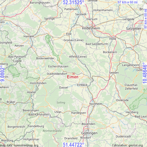
Eimen GPS coordinates[2]
51° 52' 59.988" North, 9° 46' 59.988" East
| Map corner | latitude | longitude |
|---|---|---|
| Upper-left | 52.31525°, | 9.0802° |
| Center: | 51.88333°, | 9.78333° |
| Lower-right: | 51.44722°, | 10.48646° |
| Map W x H: | 96.5×96.5 km | = 60×60mi |
| max Lat: | 55.01917° ⇑29.1% North |
| Eimen: | 51.88333° |
| min Lat: | ⇓70.9% South 47.40724° |
| min Long | Eimen | max Long |
| 5.92978° | 9.78333° | 14.98853° |
| W 46.9%⇐ | ⇒53.1% E |
Elevation
Elevation of Eimen is 216 m = 709 ft, and this is 33.1 m = 109 ft below average elevation for this country.
| Max E: |
1256 m = 4121 ft | 51.3% |
| Avg. | 249.1 m = 817 ft | |
| Eimen | 216 m = 709 ft | |
Min E: |
-5 m = -16 ft | 48.7% |
See also: Germany elevation on elevation.city.
Geographical zone
Eimen is located in North temperate zone (between Tropic of Cancer and the Arctic Circle). Distance of this North polar circle is 1632.3 km =1014.3 mi to North.| Distance of | km | miles | from Eimen |
|---|---|---|---|
| North Pole | 4238.2 | 2633.5 | to North |
| Arctic Circle | 1632.3 | 1014.3 | to North |
| Tropic Cancer | 3163 | 1965.4 | to South |
| Equator | 5768.9 | 3584.6 | to South |


Nearby cities:
15 places around Eimen: (largest is in red/bold)
• Alfeld
11.5 km =7.1 mi,  12°
12°
• Coppengrave
11.6 km =7.2 mi,  342°
342°
• Dassel
11.1 km =6.9 mi,  215°
215°
• Delligsen
6.6 km =4.1 mi, 11°
• Einbeck
9.2 km =5.7 mi,  139°
139°
• Eschershausen
10.8 km =6.7 mi,  296°
296°
• Everode
11.8 km =7.3 mi,  50°
50°
• Freden
9 km =5.6 mi,  56°
56°
• Heinade
11.7 km =7.3 mi,  241°
241°
• Holzen
9.7 km =6 mi, 304°
• Kreiensen
12.9 km =8 mi,  104°
104°
• Lenne
7 km =4.3 mi,  279°
279°
• Stadtoldendorf
10.8 km =6.7 mi,  269°
269°
• Wangelnstedt
7.1 km =4.4 mi,  254°
254°
• Winzenburg
11.7 km =7.3 mi, 61°
Sources, notices
• [Note1] Compared only with cities in Germany existing in our database
• [Src1] Map data: © OpenStreetMap contributors (CC-BY-SA)
• [Src2] Other city data from geonames.org with taken over terms of usage.
• [Src3] Geographical zone / Annual Mean Temperature by Robert A. Rohde @ Wikipedia
