Frankenberg geodata
Frankenberg (Hesse) is a populated place; located in Germany in Europe/Berlin (GMT+2) time zone. With population of 19,276 people, there are 808 cities with bigger population in this country. Compared to other cities in Germany, 59.2% of cities are located further ↓South; 67.9% of cities are located further →East and 63.8% of cities have lower elevation than Frankenberg. Note1
Administrative division(s):
- Level 1: Hesse
- Level 2: Regierungsbezirk Kassel
- Level 3: Landkreis Waldeck-Frankenberg
- Level 4: Frankenberg (Eder)


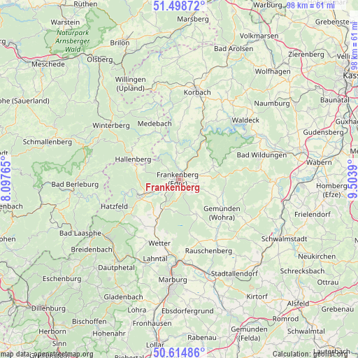
Frankenberg GPS coordinates[2]
51° 3' 32.04" North, 8° 48' 2.772" East
| Map corner | latitude | longitude |
|---|---|---|
| Upper-left | 51.49872°, | 8.09765° |
| Center: | 51.0589°, | 8.80077° |
| Lower-right: | 50.61486°, | 9.5039° |
| Map W x H: | 98.3×98.3 km | = 61.1×61.1mi |
| max Lat: | 55.01917° ⇑40.8% North |
| Frankenberg: | 51.0589° |
| min Lat: | ⇓59.2% South 47.40724° |
| min Long | Frankenberg | max Long |
| 5.92978° | 8.80077° | 14.98853° |
| W 32.1%⇐ | ⇒67.9% E |
Elevation
Elevation of Frankenberg is 314 m = 1030 ft, and this is 64.9 m = 213 ft above average elevation for this country.
| Max E: |
1256 m = 4121 ft | 36.2% |
| Frankenberg | 314 m 1030 ft | |
| Avg. | 249.1 m = 817 ft | |
Min E: |
-5 m = -16 ft | 63.8% |
See also: Germany elevation on elevation.city.
Geographical zone
Frankenberg is located in North temperate zone (between Tropic of Cancer and the Arctic Circle). Distance of this North polar circle is 1724 km =1071.2 mi to North.| Distance of | km | miles | from Frankenberg |
|---|---|---|---|
| North Pole | 4329.8 | 2690.4 | to North |
| Arctic Circle | 1724 | 1071.2 | to North |
| Tropic Cancer | 3071.3 | 1908.4 | to South |
| Equator | 5677.2 | 3527.6 | to South |


Nearby cities:
15 places around Frankenberg: (largest is in red/bold)
• Allendorf
9.5 km =5.9 mi,  250°
250°
• Battenberg
11.9 km =7.4 mi, 245°
• Bromskirchen
12.8 km =8 mi,  287°
287°
• Frankenau
10.1 km =6.3 mi,  68°
68°
• Gemünden an der Wohra
15.1 km =9.4 mi,  128°
128°
• Haina
12.6 km =7.8 mi,  105°
105°
• Hallenberg
13.9 km =8.6 mi, 294°
• Hatzfeld
19.3 km =12 mi, 247°
• Medebach
16.7 km =10.4 mi,  336°
336°
• Münchhausen
12.3 km =7.6 mi,  207°
207°
• Rauschenberg
21.2 km =13.2 mi,  157°
157°
• Reinhardshausen
20 km =12.4 mi, 72°
• Rosenthal
10.5 km =6.5 mi,  153°
153°
• Vöhl
19.2 km =11.9 mi,  31°
31°
• Wetter
18.2 km =11.3 mi,  197°
197°
Sources, notices
• [Note1] Compared only with cities in Germany existing in our database
• [Src1] Map data: © OpenStreetMap contributors (CC-BY-SA)
• [Src2] Other city data from geonames.org with taken over terms of usage.
• [Src3] Geographical zone / Annual Mean Temperature by Robert A. Rohde @ Wikipedia
