Haina geodata
Haina (Hesse) is a populated place; located in Germany in Europe/Berlin (GMT+2) time zone. With population of 3,662 people, there are 3505 cities with bigger population in this country. Compared to other cities in Germany, 58.6% of cities are located further ↓South; 65.8% of cities are located further →East and 65.5% of cities have lower elevation than Haina. Note1
Administrative division(s):
- Level 1: Hesse
- Level 2: Regierungsbezirk Kassel
- Level 3: Landkreis Waldeck-Frankenberg
- Level 4: Haina (Kloster)


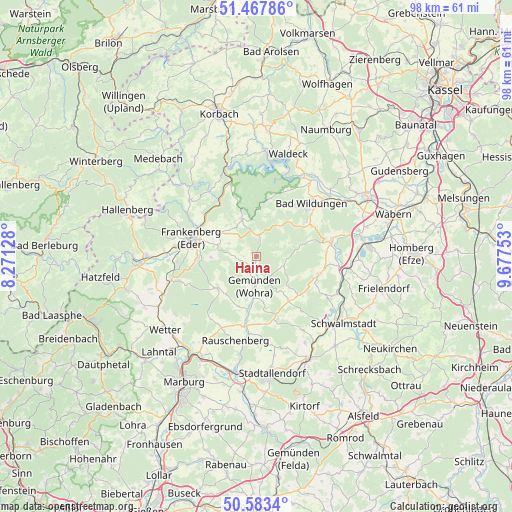
Haina GPS coordinates[2]
51° 1' 39.864" North, 8° 58' 27.876" East
| Map corner | latitude | longitude |
|---|---|---|
| Upper-left | 51.46786°, | 8.27128° |
| Center: | 51.02774°, | 8.97441° |
| Lower-right: | 50.5834°, | 9.67753° |
| Map W x H: | 98.3×98.3 km | = 61.1×61.1mi |
| max Lat: | 55.01917° ⇑41.4% North |
| Haina: | 51.02774° |
| min Lat: | ⇓58.6% South 47.40724° |
| min Long | Haina | max Long |
| 5.92978° | 8.97441° | 14.98853° |
| W 34.2%⇐ | ⇒65.8% E |
Elevation
Elevation of Haina is 325 m = 1066 ft, and this is 75.9 m = 249 ft above average elevation for this country.
| Max E: |
1256 m = 4121 ft | 34.5% |
| Haina | 325 m 1066 ft | |
| Avg. | 249.1 m = 817 ft | |
Min E: |
-5 m = -16 ft | 65.5% |
See also: Germany elevation on elevation.city.
Geographical zone
Haina is located in North temperate zone (between Tropic of Cancer and the Arctic Circle). Distance of this North polar circle is 1727.4 km =1073.4 mi to North.| Distance of | km | miles | from Haina |
|---|---|---|---|
| North Pole | 4333.3 | 2692.6 | to North |
| Arctic Circle | 1727.4 | 1073.4 | to North |
| Tropic Cancer | 3067.8 | 1906.2 | to South |
| Equator | 5673.8 | 3525.5 | to South |


Nearby cities:
15 places around Haina: (largest is in red/bold)
• Bad Wildungen
14.7 km =9.1 mi,  45°
45°
• Frankenau
7.7 km =4.8 mi,  338°
338°
• Frankenberg
12.6 km =7.8 mi,  285°
285°
• Gemünden an der Wohra
6 km =3.7 mi,  183°
183°
• Gilserberg
10.8 km =6.7 mi,  143°
143°
• Hemfurth-Edersee
17.4 km =10.8 mi,  18°
18°
• Jesberg
12.7 km =7.9 mi,  104°
104°
• Münchhausen
19.4 km =12.1 mi,  247°
247°
• Neuental
17.2 km =10.7 mi, 100°
• Rauschenberg
16.5 km =10.3 mi,  193°
193°
• Reinhardshausen
11.7 km =7.3 mi,  37°
37°
• Rosenthal
9.6 km =6 mi,  231°
231°
• Schwalmstadt
19.9 km =12.4 mi,  121°
121°
• Vöhl
19.9 km =12.4 mi,  354°
354°
• Waldeck
20.8 km =12.9 mi, 17°
Sources, notices
• [Note1] Compared only with cities in Germany existing in our database
• [Src1] Map data: © OpenStreetMap contributors (CC-BY-SA)
• [Src2] Other city data from geonames.org with taken over terms of usage.
• [Src3] Geographical zone / Annual Mean Temperature by Robert A. Rohde @ Wikipedia
