Hatzfeld geodata
Hatzfeld (Hesse) is a populated place; located in Germany in Europe/Berlin (GMT+2) time zone. With population of 3,409 people, there are 3681 cities with bigger population in this country. Compared to other cities in Germany, 58% of cities are located further ↓South; 70.7% of cities are located further →East and 68.7% of cities have lower elevation than Hatzfeld. Note1
Administrative division(s):
- Level 1: Hesse
- Level 2: Regierungsbezirk Kassel
- Level 3: Landkreis Waldeck-Frankenberg
- Level 4: Hatzfeld (Eder)


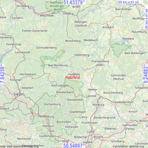
Hatzfeld GPS coordinates[2]
50° 59' 36.024" North, 8° 32' 44.52" East
| Map corner | latitude | longitude |
|---|---|---|
| Upper-left | 51.43379°, | 7.84258° |
| Center: | 50.99334°, | 8.5457° |
| Lower-right: | 50.54867°, | 9.24883° |
| Map W x H: | 98.4×98.4 km | = 61.1×61.1mi |
| max Lat: | 55.01917° ⇑42% North |
| Hatzfeld: | 50.99334° |
| min Lat: | ⇓58% South 47.40724° |
| min Long | Hatzfeld | max Long |
| 5.92978° | 8.5457° | 14.98853° |
| W 29.3%⇐ | ⇒70.7% E |
Elevation
Elevation of Hatzfeld is 348 m = 1142 ft, and this is 98.9 m = 324 ft above average elevation for this country.
| Max E: |
1256 m = 4121 ft | 31.3% |
| Hatzfeld | 348 m 1142 ft | |
| Avg. | 249.1 m = 817 ft | |
Min E: |
-5 m = -16 ft | 68.7% |
See also: Germany elevation on elevation.city.
Geographical zone
Hatzfeld is located in North temperate zone (between Tropic of Cancer and the Arctic Circle). Distance of this North polar circle is 1731.2 km =1075.7 mi to North.| Distance of | km | miles | from Hatzfeld |
|---|---|---|---|
| North Pole | 4337.1 | 2694.9 | to North |
| Arctic Circle | 1731.2 | 1075.7 | to North |
| Tropic Cancer | 3064 | 1903.9 | to South |
| Equator | 5669.9 | 3523.1 | to South |


Nearby cities:
15 places around Hatzfeld: (largest is in red/bold)
• Allendorf
9.7 km =6 mi,  65°
65°
• Bad Berleburg
12.6 km =7.8 mi,  301°
301°
• Bad Laasphe
10.9 km =6.8 mi,  230°
230°
• Battenberg
7.4 km =4.6 mi, 71°
• Biedenkopf
9.2 km =5.7 mi,  186°
186°
• Breidenbach
13.3 km =8.3 mi,  207°
207°
• Bromskirchen
12.5 km =7.8 mi,  26°
26°
• Cölbe
22.9 km =14.2 mi,  133°
133°
• Erndtebrück
20.5 km =12.7 mi,  268°
268°
• Frankenberg
19.3 km =12 mi, 67°
• Hallenberg
14.1 km =8.8 mi,  21°
21°
• Münchhausen
12.6 km =7.8 mi,  106°
106°
• Rosenthal
22.6 km =14 mi,  95°
95°
• Wetter
16 km =9.9 mi, 129°
• Winterberg
22.2 km =13.8 mi,  358°
358°
Sources, notices
• [Note1] Compared only with cities in Germany existing in our database
• [Src1] Map data: © OpenStreetMap contributors (CC-BY-SA)
• [Src2] Other city data from geonames.org with taken over terms of usage.
• [Src3] Geographical zone / Annual Mean Temperature by Robert A. Rohde @ Wikipedia
