Vöhl geodata
Vöhl (Hesse) is a seat of a fourth-order administrative division; located in Germany in Europe/Berlin (GMT+2) time zone. With population of 6,296 people, there are 2366 cities with bigger population in this country. Compared to other cities in Germany, 61.7% of cities are located further ↓South; 66.1% of cities are located further →East and 62.2% of cities have lower elevation than Vöhl. Note1
Administrative division(s):
- Level 1: Hesse
- Level 2: Regierungsbezirk Kassel
- Level 3: Landkreis Waldeck-Frankenberg
- Level 4: Vöhl


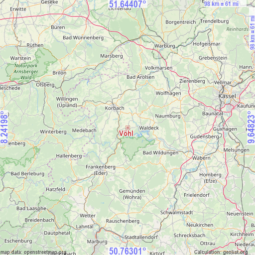
Vöhl GPS coordinates[2]
51° 12' 20.34" North, 8° 56' 42.36" East
| Map corner | latitude | longitude |
|---|---|---|
| Upper-left | 51.64407°, | 8.24198° |
| Center: | 51.20565°, | 8.9451° |
| Lower-right: | 50.76301°, | 9.64823° |
| Map W x H: | 98×98 km | = 60.9×60.9mi |
| max Lat: | 55.01917° ⇑38.3% North |
| Vöhl: | 51.20565° |
| min Lat: | ⇓61.7% South 47.40724° |
| min Long | Vöhl | max Long |
| 5.92978° | 8.9451° | 14.98853° |
| W 33.9%⇐ | ⇒66.1% E |
Elevation
Elevation of Vöhl is 303 m = 994 ft, and this is 53.9 m = 177 ft above average elevation for this country.
| Max E: |
1256 m = 4121 ft | 37.8% |
| Vöhl | 303 m 994 ft | |
| Avg. | 249.1 m = 817 ft | |
Min E: |
-5 m = -16 ft | 62.2% |
See also: Germany elevation on elevation.city.
Geographical zone
Vöhl is located in North temperate zone (between Tropic of Cancer and the Arctic Circle). Distance of this North polar circle is 1707.6 km =1061.1 mi to North.| Distance of | km | miles | from Vöhl |
|---|---|---|---|
| North Pole | 4313.5 | 2680.3 | to North |
| Arctic Circle | 1707.6 | 1061.1 | to North |
| Tropic Cancer | 3087.6 | 1918.5 | to South |
| Equator | 5693.5 | 3537.8 | to South |


Nearby cities:
15 places around Vöhl: (largest is in red/bold)
• Bad Arolsen
20 km =12.4 mi,  13°
13°
• Bad Wildungen
15.8 km =9.8 mi,  127°
127°
• Frankenau
12.6 km =7.8 mi,  183°
183°
• Frankenberg
19.2 km =11.9 mi,  211°
211°
• Fritzlar
24.5 km =15.2 mi,  109°
109°
• Haina
19.9 km =12.4 mi,  174°
174°
• Hallenberg
25 km =15.5 mi,  245°
245°
• Hemfurth-Edersee
8.3 km =5.2 mi, 113°
• Korbach
9.3 km =5.8 mi,  327°
327°
• Medebach
16.7 km =10.4 mi,  266°
266°
• Naumburg
16.1 km =10 mi,  72°
72°
• Reinhardshausen
13.8 km =8.6 mi,  139°
139°
• Sachsenhausen
6.2 km =3.9 mi,  47°
47°
• Waldeck
8.2 km =5.1 mi,  89°
89°
• Wolfhagen
20.6 km =12.8 mi, 49°
Sources, notices
• [Note1] Compared only with cities in Germany existing in our database
• [Src1] Map data: © OpenStreetMap contributors (CC-BY-SA)
• [Src2] Other city data from geonames.org with taken over terms of usage.
• [Src3] Geographical zone / Annual Mean Temperature by Robert A. Rohde @ Wikipedia
