Bad Feilnbach geodata
Bad Feilnbach (Bavaria) is a seat of a fourth-order administrative division; located in Germany in Europe/Berlin (GMT+2) time zone. With population of 7,203 people, there are 2139 cities with bigger population in this country. Compared to other cities in Germany, 98% of cities are located further ↑North; 81.9% of cities are located further ←West and 90.5% of cities have lower elevation than Bad Feilnbach. Note1
Administrative division(s):
- Level 1: Bavaria
- Level 2: Upper Bavaria
- Level 3: Landkreis Rosenheim
- Level 4: Bad Feilnbach


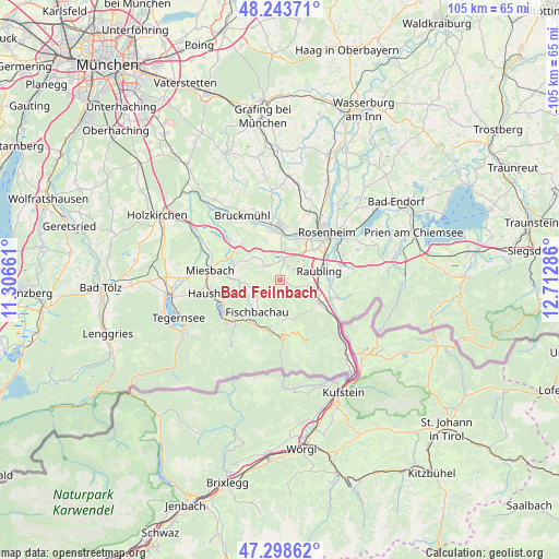
Bad Feilnbach GPS coordinates[2]
47° 46' 23.916" North, 12° 0' 35.028" East
| Map corner | latitude | longitude |
|---|---|---|
| Upper-left | 48.24371°, | 11.30661° |
| Center: | 47.77331°, | 12.00973° |
| Lower-right: | 47.29862°, | 12.71286° |
| Map W x H: | 105.1×105.1 km | = 65.3×65.3mi |
| max Lat: | 55.01917° ⇑98% North |
| Bad Feilnbach: | 47.77331° |
| min Lat: | ⇓2% South 47.40724° |
| min Long | Bad Feilnbach | max Long |
| 5.92978° | 12.00973° | 14.98853° |
| W 81.9%⇐ | ⇒18.1% E |
Elevation
Elevation of Bad Feilnbach is 520 m = 1706 ft, and this is 270.9 m = 889 ft above average elevation for this country.
| Max E: |
1256 m = 4121 ft | 9.5% |
| Bad Feilnbach | 520 m 1706 ft | |
| Avg. | 249.1 m = 817 ft | |
Min E: |
-5 m = -16 ft | 90.5% |
See also: Germany elevation on elevation.city.
Geographical zone
Bad Feilnbach is located in North temperate zone (between Tropic of Cancer and the Arctic Circle). Distance of this North polar circle is 2089.3 km =1298.2 mi to North.| Distance of | km | miles | from Bad Feilnbach |
|---|---|---|---|
| North Pole | 4695.2 | 2917.5 | to North |
| Arctic Circle | 2089.3 | 1298.2 | to North |
| Tropic Cancer | 2706 | 1681.4 | to South |
| Equator | 5311.9 | 3300.7 | to South |


Nearby cities:
15 places around Bad Feilnbach: (largest is in red/bold)
• Altenmarkt
9.4 km =5.8 mi,  85°
85°
• Bad Aibling
10.1 km =6.3 mi,  0°
0°
• Bayrischzell
11 km =6.8 mi,  178°
178°
• Brannenburg
7.2 km =4.5 mi,  121°
121°
• Burg Unter-Falkenstein
10.4 km =6.5 mi,  137°
137°
• Fischbachau
7.4 km =4.6 mi,  216°
216°
• Flintsbach
10.1 km =6.3 mi, 121°
• Irschenberg
9.6 km =6 mi,  313°
313°
• Kolbermoor
9.5 km =5.9 mi,  26°
26°
• Neubeuern
9.7 km =6 mi, 89°
• Nußdorf am Inn
11.5 km =7.1 mi,  107°
107°
• Raubling
7.8 km =4.8 mi,  75°
75°
• Rohrdorf
12.3 km =7.6 mi, 77°
• Rosenheim
12.5 km =7.8 mi,  42°
42°
• Schliersee
12 km =7.5 mi,  249°
249°
Sources, notices
• [Note1] Compared only with cities in Germany existing in our database
• [Src1] Map data: © OpenStreetMap contributors (CC-BY-SA)
• [Src2] Other city data from geonames.org with taken over terms of usage.
• [Src3] Geographical zone / Annual Mean Temperature by Robert A. Rohde @ Wikipedia
