Flintsbach geodata
Flintsbach (Bavaria) is a populated place; located in Germany in Europe/Berlin (GMT+2) time zone. With population of 2,870 people, there are 4124 cities with bigger population in this country. Compared to other cities in Germany, 98.5% of cities are located further ↑North; 83.5% of cities are located further ←West and 85.8% of cities have lower elevation than Flintsbach. Note1
Administrative division(s):
- Level 1: Bavaria
- Level 2: Upper Bavaria
- Level 3: Landkreis Rosenheim
- Level 4: Flintsbach a.Inn


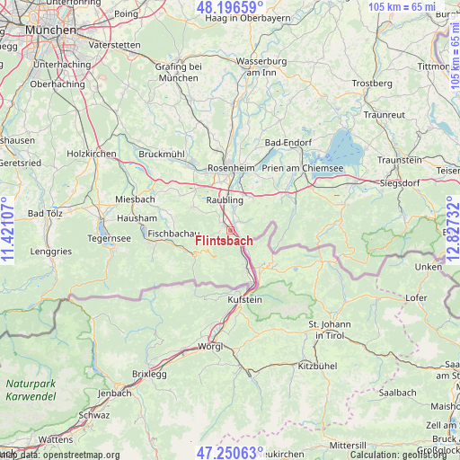
Flintsbach GPS coordinates[2]
47° 43' 32.736" North, 12° 7' 27.084" East
| Map corner | latitude | longitude |
|---|---|---|
| Upper-left | 48.19659°, | 11.42107° |
| Center: | 47.72576°, | 12.12419° |
| Lower-right: | 47.25063°, | 12.82732° |
| Map W x H: | 105.2×105.2 km | = 65.4×65.4mi |
| max Lat: | 55.01917° ⇑98.5% North |
| Flintsbach: | 47.72576° |
| min Lat: | ⇓1.5% South 47.40724° |
| min Long | Flintsbach | max Long |
| 5.92978° | 12.12419° | 14.98853° |
| W 83.5%⇐ | ⇒16.5% E |
Elevation
Elevation of Flintsbach is 475 m = 1558 ft, and this is 225.9 m = 741 ft above average elevation for this country.
| Max E: |
1256 m = 4121 ft | 14.2% |
| Flintsbach | 475 m 1558 ft | |
| Avg. | 249.1 m = 817 ft | |
Min E: |
-5 m = -16 ft | 85.8% |
See also: Germany elevation on elevation.city.
Geographical zone
Flintsbach is located in North temperate zone (between Tropic of Cancer and the Arctic Circle). Distance of this North polar circle is 2094.6 km =1301.5 mi to North.| Distance of | km | miles | from Flintsbach |
|---|---|---|---|
| North Pole | 4700.5 | 2920.8 | to North |
| Arctic Circle | 2094.6 | 1301.5 | to North |
| Tropic Cancer | 2700.7 | 1678.1 | to South |
| Equator | 5306.6 | 3297.4 | to South |


Nearby cities:
15 places around Flintsbach: (largest is in red/bold)
• Altenmarkt
6 km =3.7 mi,  8°
8°
• Bad Feilnbach
10.1 km =6.3 mi,  301°
301°
• Bayrischzell
10 km =6.2 mi,  235°
235°
• Brannenburg
2.9 km =1.8 mi, 302°
• Burg Unter-Falkenstein
2.8 km =1.7 mi,  211°
211°
• Fischbachau
13 km =8.1 mi,  266°
266°
• Kiefersfelden
13.4 km =8.3 mi,  158°
158°
• Kolbermoor
14.4 km =8.9 mi,  342°
342°
• Neubeuern
5.5 km =3.4 mi, 12°
• Nußdorf am Inn
3 km =1.9 mi,  52°
52°
• Oberaudorf
9.3 km =5.8 mi, 157°
• Raubling
7.3 km =4.5 mi,  352°
352°
• Riedering
14 km =8.7 mi,  26°
26°
• Rohrdorf
8.6 km =5.3 mi,  23°
23°
• Samerberg
7.6 km =4.7 mi,  41°
41°
Sources, notices
• [Note1] Compared only with cities in Germany existing in our database
• [Src1] Map data: © OpenStreetMap contributors (CC-BY-SA)
• [Src2] Other city data from geonames.org with taken over terms of usage.
• [Src3] Geographical zone / Annual Mean Temperature by Robert A. Rohde @ Wikipedia
