Bayrischzell geodata
Bayrischzell (Bavaria) is a seat of a fourth-order administrative division; located in Germany in Europe/Berlin (GMT+2) time zone. With population of 1,601 people, there are 5679 cities with bigger population in this country. Compared to other cities in Germany, 99% of cities are located further ↑North; 81.9% of cities are located further ←West and 99.2% of cities have lower elevation than Bayrischzell. Note1
Administrative division(s):
- Level 1: Bavaria
- Level 2: Upper Bavaria
- Level 3: Landkreis Miesbach
- Level 4: Bayrischzell


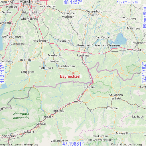
Bayrischzell GPS coordinates[2]
47° 40' 27.84" North, 12° 0' 52.164" East
| Map corner | latitude | longitude |
|---|---|---|
| Upper-left | 48.1457°, | 11.31137° |
| Center: | 47.6744°, | 12.01449° |
| Lower-right: | 47.19881°, | 12.71762° |
| Map W x H: | 105.3×105.3 km | = 65.4×65.4mi |
| max Lat: | 55.01917° ⇑99% North |
| Bayrischzell: | 47.6744° |
| min Lat: | ⇓1% South 47.40724° |
| min Long | Bayrischzell | max Long |
| 5.92978° | 12.01449° | 14.98853° |
| W 81.9%⇐ | ⇒18.1% E |
Elevation
Elevation of Bayrischzell is 803 m = 2635 ft, and this is 553.9 m = 1817 ft above average elevation for this country.
| Max E: |
1256 m = 4121 ft | 0.8% |
| Bayrischzell | 803 m 2635 ft | |
| Avg. | 249.1 m = 817 ft | |
Min E: |
-5 m = -16 ft | 99.2% |
See also: Germany elevation on elevation.city.
Geographical zone
Bayrischzell is located in North temperate zone (between Tropic of Cancer and the Arctic Circle). Distance of this North polar circle is 2100.3 km =1305.1 mi to North.| Distance of | km | miles | from Bayrischzell |
|---|---|---|---|
| North Pole | 4706.2 | 2924.3 | to North |
| Arctic Circle | 2100.3 | 1305.1 | to North |
| Tropic Cancer | 2695 | 1674.6 | to South |
| Equator | 5300.9 | 3293.8 | to South |


Nearby cities:
15 places around Bayrischzell: (largest is in red/bold)
• Altenmarkt
14.8 km =9.2 mi,  37°
37°
• Bad Feilnbach
11 km =6.8 mi,  358°
358°
• Brannenburg
9.3 km =5.8 mi, 38°
• Burg Unter-Falkenstein
7.5 km =4.7 mi,  63°
63°
• Fischbachau
6.9 km =4.3 mi,  316°
316°
• Flintsbach
10 km =6.2 mi, 55°
• Hausham
15.3 km =9.5 mi,  301°
301°
• Kiefersfelden
14.8 km =9.2 mi,  116°
116°
• Neubeuern
14.5 km =9 mi, 40°
• Nußdorf am Inn
13 km =8.1 mi,  54°
54°
• Oberaudorf
12.2 km =7.6 mi,  103°
103°
• Raubling
14.8 km =9.2 mi,  29°
29°
• Rohrdorf
17.9 km =11.1 mi, 40°
• Samerberg
17.4 km =10.8 mi, 49°
• Schliersee
13.5 km =8.4 mi, 300°
Sources, notices
• [Note1] Compared only with cities in Germany existing in our database
• [Src1] Map data: © OpenStreetMap contributors (CC-BY-SA)
• [Src2] Other city data from geonames.org with taken over terms of usage.
• [Src3] Geographical zone / Annual Mean Temperature by Robert A. Rohde @ Wikipedia
