Fahrenbach geodata
Fahrenbach (Baden-Württemberg) is a seat of a fourth-order administrative division; located in Germany in Europe/Berlin (GMT+2) time zone. With population of 2,898 people, there are 4095 cities with bigger population in this country. Compared to other cities in Germany, 76.8% of cities are located further ↑North; 63.1% of cities are located further →East and 71.1% of cities have lower elevation than Fahrenbach. Note1
Administrative division(s):
- Level 1: Baden-Württemberg
- Level 2: Karlsruhe Region
- Level 3: Neckar-Odenwald-Kreis
- Level 4: Fahrenbach


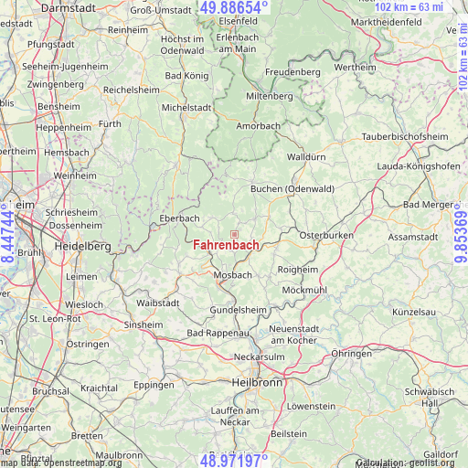
Fahrenbach GPS coordinates[2]
49° 25' 53.004" North, 9° 9' 2.016" East
| Map corner | latitude | longitude |
|---|---|---|
| Upper-left | 49.88654°, | 8.44744° |
| Center: | 49.43139°, | 9.15056° |
| Lower-right: | 48.97197°, | 9.85369° |
| Map W x H: | 101.7×101.7 km | = 63.2×63.2mi |
| max Lat: | 55.01917° ⇑76.8% North |
| Fahrenbach: | 49.43139° |
| min Lat: | ⇓23.2% South 47.40724° |
| min Long | Fahrenbach | max Long |
| 5.92978° | 9.15056° | 14.98853° |
| W 36.9%⇐ | ⇒63.1% E |
Elevation
Elevation of Fahrenbach is 367 m = 1204 ft, and this is 117.9 m = 387 ft above average elevation for this country.
| Max E: |
1256 m = 4121 ft | 28.9% |
| Fahrenbach | 367 m 1204 ft | |
| Avg. | 249.1 m = 817 ft | |
Min E: |
-5 m = -16 ft | 71.1% |
See also: Germany elevation on elevation.city.
Geographical zone
Fahrenbach is located in North temperate zone (between Tropic of Cancer and the Arctic Circle). Distance of this North polar circle is 1904.9 km =1183.6 mi to North.| Distance of | km | miles | from Fahrenbach |
|---|---|---|---|
| North Pole | 4510.8 | 2802.9 | to North |
| Arctic Circle | 1904.9 | 1183.6 | to North |
| Tropic Cancer | 2890.3 | 1795.9 | to South |
| Equator | 5496.3 | 3415.2 | to South |


Nearby cities:
15 places around Fahrenbach: (largest is in red/bold)
• Aglasterhausen
14.4 km =8.9 mi,  235°
235°
• Billigheim
11.9 km =7.4 mi,  140°
140°
• Binau
9.7 km =6 mi,  223°
223°
• Eberbach
12.2 km =7.6 mi,  288°
288°
• Haßmersheim
14.6 km =9.1 mi,  180°
180°
• Limbach
5.5 km =3.4 mi,  52°
52°
• Mosbach
8.7 km =5.4 mi, 179°
• Mudau
12.1 km =7.5 mi,  18°
18°
• Neckargerach
7 km =4.3 mi, 240°
• Neckarzimmern
12.5 km =7.8 mi,  185°
185°
• Neunkirchen
11.3 km =7 mi, 243°
• Obrigheim
9.8 km =6.1 mi,  206°
206°
• Roigheim
15.6 km =9.7 mi,  118°
118°
• Seckach
13.3 km =8.3 mi,  84°
84°
• Zwingenberg
8.1 km =5 mi,  260°
260°
Sources, notices
• [Note1] Compared only with cities in Germany existing in our database
• [Src1] Map data: © OpenStreetMap contributors (CC-BY-SA)
• [Src2] Other city data from geonames.org with taken over terms of usage.
• [Src3] Geographical zone / Annual Mean Temperature by Robert A. Rohde @ Wikipedia
