Mudau geodata
Mudau (Baden-Württemberg) is a seat of a fourth-order administrative division; located in Germany in Europe/Berlin (GMT+2) time zone. With population of 5,094 people, there are 2793 cities with bigger population in this country. Compared to other cities in Germany, 75.1% of cities are located further ↑North; 62.3% of cities are located further →East and 82.8% of cities have lower elevation than Mudau. Note1
Administrative division(s):
- Level 1: Baden-Württemberg
- Level 2: Karlsruhe Region
- Level 3: Neckar-Odenwald-Kreis
- Level 4: Mudau


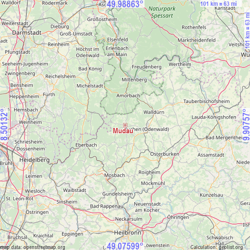
Mudau GPS coordinates[2]
49° 32' 3.984" North, 9° 12' 15.984" East
| Map corner | latitude | longitude |
|---|---|---|
| Upper-left | 49.98863°, | 8.50132° |
| Center: | 49.53444°, | 9.20444° |
| Lower-right: | 49.07599°, | 9.90757° |
| Map W x H: | 101.5×101.5 km | = 63.1×63.1mi |
| max Lat: | 55.01917° ⇑75.1% North |
| Mudau: | 49.53444° |
| min Lat: | ⇓24.9% South 47.40724° |
| min Long | Mudau | max Long |
| 5.92978° | 9.20444° | 14.98853° |
| W 37.7%⇐ | ⇒62.3% E |
Elevation
Elevation of Mudau is 452 m = 1483 ft, and this is 202.9 m = 666 ft above average elevation for this country.
| Max E: |
1256 m = 4121 ft | 17.2% |
| Mudau | 452 m 1483 ft | |
| Avg. | 249.1 m = 817 ft | |
Min E: |
-5 m = -16 ft | 82.8% |
See also: Germany elevation on elevation.city.
Geographical zone
Mudau is located in North temperate zone (between Tropic of Cancer and the Arctic Circle). Distance of this North polar circle is 1893.5 km =1176.6 mi to North.| Distance of | km | miles | from Mudau |
|---|---|---|---|
| North Pole | 4499.3 | 2795.7 | to North |
| Arctic Circle | 1893.5 | 1176.6 | to North |
| Tropic Cancer | 2901.8 | 1803.1 | to South |
| Equator | 5507.7 | 3422.3 | to South |


Nearby cities:
15 places around Mudau: (largest is in red/bold)
• Beerfelden
17 km =10.6 mi,  282°
282°
• Buchen in Odenwald
8.6 km =5.3 mi,  97°
97°
• Eberbach
17.2 km =10.7 mi,  244°
244°
• Fahrenbach
12.1 km =7.5 mi,  198°
198°
• Hesseneck
10.9 km =6.8 mi,  291°
291°
• Höpfingen
17.8 km =11.1 mi,  64°
64°
• Kirchzell
9.5 km =5.9 mi,  348°
348°
• Limbach
8.1 km =5 mi,  176°
176°
• Miltenberg
19.4 km =12.1 mi,  13°
13°
• Neckargerach
18 km =11.2 mi,  213°
213°
• Osterburken
19.6 km =12.2 mi,  126°
126°
• Seckach
13.9 km =8.6 mi,  137°
137°
• Walldürn
12.9 km =8 mi, 64°
• Weilbach
14.9 km =9.3 mi,  3°
3°
• Zwingenberg
17.4 km =10.8 mi,  222°
222°
Sources, notices
• [Note1] Compared only with cities in Germany existing in our database
• [Src1] Map data: © OpenStreetMap contributors (CC-BY-SA)
• [Src2] Other city data from geonames.org with taken over terms of usage.
• [Src3] Geographical zone / Annual Mean Temperature by Robert A. Rohde @ Wikipedia
