Roigheim geodata
Roigheim (Baden-Württemberg) is a seat of a fourth-order administrative division; located in Germany in Europe/Berlin (GMT+2) time zone. With population of 1,462 people, there are 5953 cities with bigger population in this country. Compared to other cities in Germany, 77.7% of cities are located further ↑North; 60.2% of cities are located further →East and 51.3% of cities have higher elevation than Roigheim. Note1
Administrative division(s):
- Level 1: Baden-Württemberg
- Level 2: Regierungsbezirk Stuttgart
- Level 3: Landkreis Heilbronn
- Level 4: Roigheim


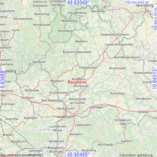
Roigheim GPS coordinates[2]
49° 21' 52.992" North, 9° 20' 24" East
| Map corner | latitude | longitude |
|---|---|---|
| Upper-left | 49.82049°, | 8.63688° |
| Center: | 49.36472°, | 9.34° |
| Lower-right: | 48.90468°, | 10.04313° |
| Map W x H: | 101.8×101.8 km | = 63.3×63.3mi |
| max Lat: | 55.01917° ⇑77.7% North |
| Roigheim: | 49.36472° |
| min Lat: | ⇓22.3% South 47.40724° |
| min Long | Roigheim | max Long |
| 5.92978° | 9.34° | 14.98853° |
| W 39.8%⇐ | ⇒60.2% E |
Elevation
Elevation of Roigheim is 216 m = 709 ft, and this is 33.1 m = 109 ft below average elevation for this country.
| Max E: |
1256 m = 4121 ft | 51.3% |
| Avg. | 249.1 m = 817 ft | |
| Roigheim | 216 m = 709 ft | |
Min E: |
-5 m = -16 ft | 48.7% |
See also: Germany elevation on elevation.city.
Geographical zone
Roigheim is located in North temperate zone (between Tropic of Cancer and the Arctic Circle). Distance of this North polar circle is 1912.3 km =1188.2 mi to North.| Distance of | km | miles | from Roigheim |
|---|---|---|---|
| North Pole | 4518.2 | 2807.5 | to North |
| Arctic Circle | 1912.3 | 1188.2 | to North |
| Tropic Cancer | 2882.9 | 1791.4 | to South |
| Equator | 5488.8 | 3410.6 | to South |


Nearby cities:
15 places around Roigheim: (largest is in red/bold)
• Adelsheim
5.6 km =3.5 mi,  42°
42°
• Billigheim
6.5 km =4 mi,  253°
253°
• Fahrenbach
15.6 km =9.7 mi,  298°
298°
• Haßmersheim
15.5 km =9.6 mi,  242°
242°
• Jagsthausen
11.1 km =6.9 mi,  122°
122°
• Limbach
14.3 km =8.9 mi,  319°
319°
• Mosbach
13.7 km =8.5 mi,  264°
264°
• Möckmühl
4.6 km =2.9 mi,  163°
163°
• Neudenau
9.6 km =6 mi,  212°
212°
• Neuenstadt am Kocher
14.4 km =8.9 mi,  182°
182°
• Oedheim
15.2 km =9.4 mi,  204°
204°
• Osterburken
9.4 km =5.8 mi, 39°
• Rosenberg
14 km =8.7 mi, 43°
• Seckach
8.6 km =5.3 mi,  357°
357°
• Widdern
7.9 km =4.9 mi,  130°
130°
Sources, notices
• [Note1] Compared only with cities in Germany existing in our database
• [Src1] Map data: © OpenStreetMap contributors (CC-BY-SA)
• [Src2] Other city data from geonames.org with taken over terms of usage.
• [Src3] Geographical zone / Annual Mean Temperature by Robert A. Rohde @ Wikipedia
