Drentwede geodata
Drentwede (Lower Saxony) is a seat of a fourth-order administrative division; located in Germany in Europe/Berlin (GMT+2) time zone. With population of 1,050 people, there are 7002 cities with bigger population in this country. Compared to other cities in Germany, 80% of cities are located further ↓South; 70.5% of cities are located further →East and 80.2% of cities have higher elevation than Drentwede. Note1


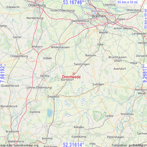
Drentwede GPS coordinates[2]
52° 44' 37.968" North, 8° 33' 54.144" East
| Map corner | latitude | longitude |
|---|---|---|
| Upper-left | 53.16746°, | 7.86192° |
| Center: | 52.74388°, | 8.56504° |
| Lower-right: | 52.31614°, | 9.26817° |
| Map W x H: | 94.7×94.7 km | = 58.8×58.8mi |
| max Lat: | 55.01917° ⇑20% North |
| Drentwede: | 52.74388° |
| min Lat: | ⇓80% South 47.40724° |
| min Long | Drentwede | max Long |
| 5.92978° | 8.56504° | 14.98853° |
| W 29.5%⇐ | ⇒70.5% E |
Elevation
Elevation of Drentwede is 46 m = 151 ft, and this is 203.1 m = 666 ft below average elevation for this country.
| Max E: |
1256 m = 4121 ft | 80.2% |
| Avg. | 249.1 m = 817 ft | |
| Drentwede | 46 m = 151 ft | |
Min E: |
-5 m = -16 ft | 19.8% |
See also: Germany elevation on elevation.city.
Geographical zone
Drentwede is located in North temperate zone (between Tropic of Cancer and the Arctic Circle). Distance of this North polar circle is 1536.6 km =954.8 mi to North.| Distance of | km | miles | from Drentwede |
|---|---|---|---|
| North Pole | 4142.5 | 2574 | to North |
| Arctic Circle | 1536.6 | 954.8 | to North |
| Tropic Cancer | 3258.7 | 2024.9 | to South |
| Equator | 5864.6 | 3644.1 | to South |


Nearby cities:
15 places around Drentwede: (largest is in red/bold)
• Barnstorf
5.6 km =3.5 mi,  228°
228°
• Barver
13.8 km =8.6 mi,  172°
172°
• Beckeln
13.7 km =8.5 mi,  5°
5°
• Colnrade
11.4 km =7.1 mi,  331°
331°
• Dickel
12.7 km =7.9 mi,  209°
209°
• Ehrenburg
9.1 km =5.7 mi,  85°
85°
• Eydelstedt
5.9 km =3.7 mi,  192°
192°
• Freistatt
14.7 km =9.1 mi,  156°
156°
• Goldenstedt
10.2 km =6.3 mi,  298°
298°
• Neuenkirchen
13 km =8.1 mi,  73°
73°
• Rehden
15.9 km =9.9 mi,  200°
200°
• Scholen
13.6 km =8.5 mi, 94°
• Twistringen
8 km =5 mi,  39°
39°
• Wehrbleck
15.3 km =9.5 mi,  146°
146°
• Winkelsett
13.8 km =8.6 mi,  351°
351°
Sources, notices
• [Note1] Compared only with cities in Germany existing in our database
• [Src1] Map data: © OpenStreetMap contributors (CC-BY-SA)
• [Src2] Other city data from geonames.org with taken over terms of usage.
• [Src3] Geographical zone / Annual Mean Temperature by Robert A. Rohde @ Wikipedia
