Eschwege geodata
Eschwege (Hesse) is a seat of a third-order administrative division; located in Germany in Europe/Berlin (GMT+2) time zone. With population of 21,191 people, there are 720 cities with bigger population in this country. Compared to other cities in Germany, 61.3% of cities are located further ↓South; 51% of cities are located further ←West and 57% of cities have higher elevation than Eschwege. Note1
Administrative division(s):
- Level 1: Hesse
- Level 2: Regierungsbezirk Kassel
- Level 3: Werra-Meißner-Kreis
- Level 4: Eschwege


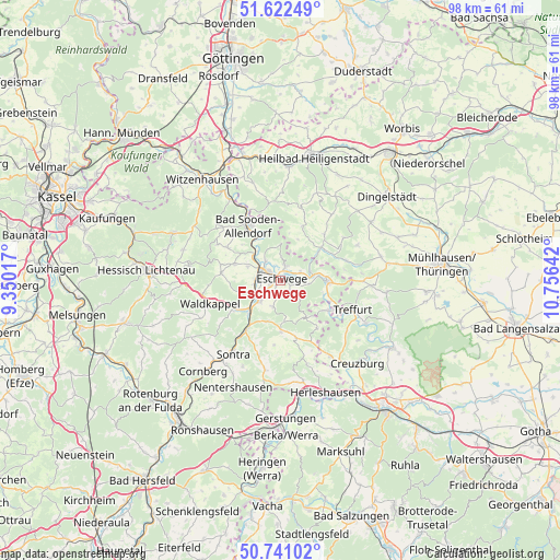
Eschwege GPS coordinates[2]
51° 11' 1.896" North, 10° 3' 11.844" East
| Map corner | latitude | longitude |
|---|---|---|
| Upper-left | 51.62249°, | 9.35017° |
| Center: | 51.18386°, | 10.05329° |
| Lower-right: | 50.74102°, | 10.75642° |
| Map W x H: | 98×98 km | = 60.9×60.9mi |
| max Lat: | 55.01917° ⇑38.7% North |
| Eschwege: | 51.18386° |
| min Lat: | ⇓61.3% South 47.40724° |
| min Long | Eschwege | max Long |
| 5.92978° | 10.05329° | 14.98853° |
| W 51%⇐ | ⇒49% E |
Elevation
Elevation of Eschwege is 175 m = 574 ft, and this is 74.1 m = 243 ft below average elevation for this country.
| Max E: |
1256 m = 4121 ft | 57% |
| Avg. | 249.1 m = 817 ft | |
| Eschwege | 175 m = 574 ft | |
Min E: |
-5 m = -16 ft | 43% |
See also: Germany elevation on elevation.city.
Geographical zone
Eschwege is located in North temperate zone (between Tropic of Cancer and the Arctic Circle). Distance of this North polar circle is 1710.1 km =1062.6 mi to North.| Distance of | km | miles | from Eschwege |
|---|---|---|---|
| North Pole | 4316 | 2681.8 | to North |
| Arctic Circle | 1710.1 | 1062.6 | to North |
| Tropic Cancer | 3085.2 | 1917.1 | to South |
| Equator | 5691.1 | 3536.3 | to South |


Nearby cities:
15 places around Eschwege: (largest is in red/bold)
• Bad Sooden-Allendorf
11.1 km =6.9 mi,  330°
330°
• Dieterode
13.3 km =8.3 mi,  14°
14°
• Eichstruth
13.1 km =8.1 mi, 9°
• Ershausen
11.1 km =6.9 mi,  42°
42°
• Geismar
9.5 km =5.9 mi,  55°
55°
• Großbartloff
13.5 km =8.4 mi, 57°
• Kella
5.9 km =3.7 mi,  20°
20°
• Mackenrode
12.9 km =8 mi,  4°
4°
• Pfaffschwende
8 km =5 mi, 23°
• Schwobfeld
11.5 km =7.1 mi, 16°
• Sickerode
8.6 km =5.3 mi,  30°
30°
• Volkerode
9.3 km =5.8 mi, 5°
• Waldkappel
13 km =8.1 mi,  250°
250°
• Wanfried
8.3 km =5.2 mi,  91°
91°
• Weißenborn
7.9 km =4.9 mi,  146°
146°
Sources, notices
• [Note1] Compared only with cities in Germany existing in our database
• [Src1] Map data: © OpenStreetMap contributors (CC-BY-SA)
• [Src2] Other city data from geonames.org with taken over terms of usage.
• [Src3] Geographical zone / Annual Mean Temperature by Robert A. Rohde @ Wikipedia
