Weißenborn geodata
Weißenborn (Hesse) is a seat of a fourth-order administrative division; located in Germany in Europe/Berlin (GMT+2) time zone. In our database, there are 11009 cities with bigger population. Compared to other cities in Germany, 60.3% of cities are located further ↓South; 51.8% of cities are located further ←West and 56.2% of cities have lower elevation than Weißenborn. Note1
Administrative division(s):
- Level 1: Hesse
- Level 2: Regierungsbezirk Kassel
- Level 3: Werra-Meißner-Kreis
- Level 4: Weißenborn


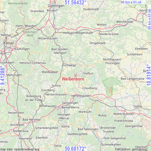
Weißenborn GPS coordinates[2]
51° 7' 30.468" North, 10° 6' 57.636" East
| Map corner | latitude | longitude |
|---|---|---|
| Upper-left | 51.56432°, | 9.41288° |
| Center: | 51.12513°, | 10.11601° |
| Lower-right: | 50.68172°, | 10.81914° |
| Map W x H: | 98.1×98.1 km | = 61×61mi |
| max Lat: | 55.01917° ⇑39.7% North |
| Weißenborn: | 51.12513° |
| min Lat: | ⇓60.3% South 47.40724° |
| min Long | Weißenborn | max Long |
| 5.92978° | 10.11601° | 14.98853° |
| W 51.8%⇐ | ⇒48.2% E |
Elevation
Elevation of Weißenborn is 267 m = 876 ft, and this is 17.9 m = 59 ft above average elevation for this country.
| Max E: |
1256 m = 4121 ft | 43.8% |
| Weißenborn | 267 m 876 ft | |
| Avg. | 249.1 m = 817 ft | |
Min E: |
-5 m = -16 ft | 56.2% |
See also: Germany elevation on elevation.city.
Geographical zone
Weißenborn is located in North temperate zone (between Tropic of Cancer and the Arctic Circle). Distance of this North polar circle is 1716.6 km =1066.6 mi to North.| Distance of | km | miles | from Weißenborn |
|---|---|---|---|
| North Pole | 4322.5 | 2685.9 | to North |
| Arctic Circle | 1716.6 | 1066.6 | to North |
| Tropic Cancer | 3078.7 | 1913 | to South |
| Equator | 5684.6 | 3532.2 | to South |


Nearby cities:
15 places around Weißenborn: (largest is in red/bold)
• Creuzburg
12.2 km =7.6 mi,  131°
131°
• Ebenshausen
13.7 km =8.5 mi,  109°
109°
• Eschwege
7.9 km =4.9 mi,  326°
326°
• Frankenroda
12 km =7.5 mi,  103°
103°
• Geismar
12.3 km =7.6 mi,  16°
16°
• Herleshausen
13.7 km =8.5 mi,  164°
164°
• Heyerode
14.9 km =9.3 mi,  72°
72°
• Ifta
8 km =5 mi,  144°
144°
• Katharinenberg
11.9 km =7.4 mi,  58°
58°
• Kella
12.2 km =7.6 mi,  349°
349°
• Pfaffschwende
13.9 km =8.6 mi,  355°
355°
• Sickerode
13.9 km =8.6 mi,  0°
0°
• Sontra
13.9 km =8.6 mi,  244°
244°
• Treffurt
8.3 km =5.2 mi,  80°
80°
• Wanfried
7.5 km =4.7 mi,  32°
32°
Sources, notices
• [Note1] Compared only with cities in Germany existing in our database
• [Src1] Map data: © OpenStreetMap contributors (CC-BY-SA)
• [Src2] Other city data from geonames.org with taken over terms of usage.
• [Src3] Geographical zone / Annual Mean Temperature by Robert A. Rohde @ Wikipedia
