Waldkappel geodata
Waldkappel (Hesse) is a populated place; located in Germany in Europe/Berlin (GMT+2) time zone. With population of 5,022 people, there are 2818 cities with bigger population in this country. Compared to other cities in Germany, 60.6% of cities are located further ↓South; 51.8% of cities are located further →East and 51.6% of cities have lower elevation than Waldkappel. Note1
Administrative division(s):
- Level 1: Hesse
- Level 2: Regierungsbezirk Kassel
- Level 3: Werra-Meißner-Kreis
- Level 4: Waldkappel


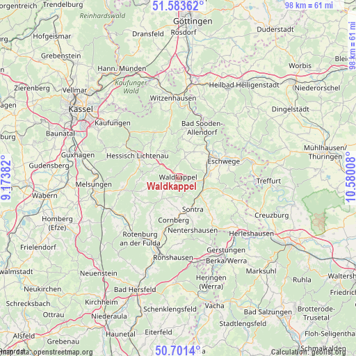
Waldkappel GPS coordinates[2]
51° 8' 40.632" North, 9° 52' 37.02" East
| Map corner | latitude | longitude |
|---|---|---|
| Upper-left | 51.58362°, | 9.17382° |
| Center: | 51.14462°, | 9.87695° |
| Lower-right: | 50.7014°, | 10.58008° |
| Map W x H: | 98.1×98.1 km | = 61×61mi |
| max Lat: | 55.01917° ⇑39.4% North |
| Waldkappel: | 51.14462° |
| min Lat: | ⇓60.6% South 47.40724° |
| min Long | Waldkappel | max Long |
| 5.92978° | 9.87695° | 14.98853° |
| W 48.2%⇐ | ⇒51.8% E |
Elevation
Elevation of Waldkappel is 237 m = 778 ft, and this is 12.1 m = 40 ft below average elevation for this country.
| Max E: |
1256 m = 4121 ft | 48.4% |
| Avg. | 249.1 m = 817 ft | |
| Waldkappel | 237 m = 778 ft | |
Min E: |
-5 m = -16 ft | 51.6% |
See also: Germany elevation on elevation.city.
Geographical zone
Waldkappel is located in North temperate zone (between Tropic of Cancer and the Arctic Circle). Distance of this North polar circle is 1714.4 km =1065.3 mi to North.| Distance of | km | miles | from Waldkappel |
|---|---|---|---|
| North Pole | 4320.3 | 2684.5 | to North |
| Arctic Circle | 1714.4 | 1065.3 | to North |
| Tropic Cancer | 3080.8 | 1914.3 | to South |
| Equator | 5686.7 | 3533.6 | to South |


Nearby cities:
15 places around Waldkappel: (largest is in red/bold)
• Alheim
19.2 km =11.9 mi,  229°
229°
• Bad Sooden-Allendorf
15.6 km =9.7 mi,  25°
25°
• Cornberg
11.5 km =7.1 mi,  185°
185°
• Eschwege
13 km =8.1 mi,  70°
70°
• Großalmerode
14.2 km =8.8 mi,  333°
333°
• Helsa
18.3 km =11.4 mi,  314°
314°
• Hessisch Lichtenau
12.6 km =7.8 mi,  298°
298°
• Kella
17.4 km =10.8 mi,  55°
55°
• Nentershausen
14.8 km =9.2 mi,  164°
164°
• Pfaffschwende
19.5 km =12.1 mi,  52°
52°
• Sontra
9.1 km =5.7 mi,  153°
153°
• Spangenberg
15.3 km =9.5 mi,  258°
258°
• Volkerode
18.9 km =11.7 mi,  44°
44°
• Wahlhausen
18.8 km =11.7 mi,  23°
23°
• Weißenborn
16.8 km =10.4 mi,  97°
97°
Sources, notices
• [Note1] Compared only with cities in Germany existing in our database
• [Src1] Map data: © OpenStreetMap contributors (CC-BY-SA)
• [Src2] Other city data from geonames.org with taken over terms of usage.
• [Src3] Geographical zone / Annual Mean Temperature by Robert A. Rohde @ Wikipedia
