Eschbach geodata
Eschbach (Rheinland-Pfalz) is a seat of a fourth-order administrative division; located in Germany in Europe/Berlin (GMT+2) time zone. With population of 198 people, there are 10479 cities with bigger population in this country. Compared to other cities in Germany, 58.8% of cities are located further ↑North; 82.5% of cities are located further →East and 70.1% of cities have lower elevation than Eschbach. Note1


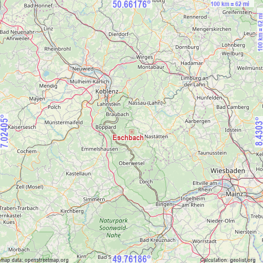
Eschbach GPS coordinates[2]
50° 12' 50.148" North, 7° 43' 37.812" East
| Map corner | latitude | longitude |
|---|---|---|
| Upper-left | 50.66176°, | 7.02405° |
| Center: | 50.21393°, | 7.72717° |
| Lower-right: | 49.76186°, | 8.4303° |
| Map W x H: | 100.1×100.1 km | = 62.2×62.2mi |
| max Lat: | 55.01917° ⇑58.8% North |
| Eschbach: | 50.21393° |
| min Lat: | ⇓41.2% South 47.40724° |
| min Long | Eschbach | max Long |
| 5.92978° | 7.72717° | 14.98853° |
| W 17.5%⇐ | ⇒82.5% E |
Elevation
Elevation of Eschbach is 359 m = 1178 ft, and this is 109.9 m = 361 ft above average elevation for this country.
| Max E: |
1256 m = 4121 ft | 29.9% |
| Eschbach | 359 m 1178 ft | |
| Avg. | 249.1 m = 817 ft | |
Min E: |
-5 m = -16 ft | 70.1% |
See also: Germany elevation on elevation.city.
Geographical zone
Eschbach is located in North temperate zone (between Tropic of Cancer and the Arctic Circle). Distance of this North polar circle is 1817.9 km =1129.6 mi to North.| Distance of | km | miles | from Eschbach |
|---|---|---|---|
| North Pole | 4423.8 | 2748.8 | to North |
| Arctic Circle | 1817.9 | 1129.6 | to North |
| Tropic Cancer | 2977.3 | 1850 | to South |
| Equator | 5583.3 | 3469.3 | to South |


Nearby cities:
15 places around Eschbach: (largest is in red/bold)
• Dachsenhausen
4.5 km =2.8 mi,  0°
0°
• Dahlheim
2.3 km =1.4 mi,  259°
259°
• Ehr
4.9 km =3 mi,  56°
56°
• Gemmerich
2.7 km =1.7 mi, 55°
• Hainau
4.1 km =2.5 mi,  75°
75°
• Himmighofen
2.7 km =1.7 mi,  94°
94°
• Kasdorf
4.1 km =2.5 mi,  101°
101°
• Kehlbach
5.5 km =3.4 mi,  24°
24°
• Lykershausen
4.6 km =2.9 mi,  250°
250°
• Niederbachheim
4.7 km =2.9 mi,  35°
35°
• Nochern
5.3 km =3.3 mi,  188°
188°
• Oberbachheim
3.9 km =2.4 mi, 22°
• Prath
3.7 km =2.3 mi,  236°
236°
• Weyer
3.5 km =2.2 mi, 192°
• Winterwerb
2.6 km =1.6 mi, 18°
Sources, notices
• [Note1] Compared only with cities in Germany existing in our database
• [Src1] Map data: © OpenStreetMap contributors (CC-BY-SA)
• [Src2] Other city data from geonames.org with taken over terms of usage.
• [Src3] Geographical zone / Annual Mean Temperature by Robert A. Rohde @ Wikipedia
