Dahlheim geodata
Dahlheim (Rheinland-Pfalz) is a seat of a fourth-order administrative division; located in Germany in Europe/Berlin (GMT+2) time zone. With population of 935 people, there are 7405 cities with bigger population in this country. Compared to other cities in Germany, 58.8% of cities are located further ↑North; 83.1% of cities are located further →East and 52.8% of cities have lower elevation than Dahlheim. Note1


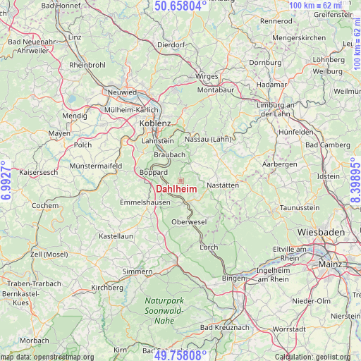
Dahlheim GPS coordinates[2]
50° 12' 36.648" North, 7° 41' 44.988" East
| Map corner | latitude | longitude |
|---|---|---|
| Upper-left | 50.65804°, | 6.9927° |
| Center: | 50.21018°, | 7.69583° |
| Lower-right: | 49.75808°, | 8.39895° |
| Map W x H: | 100.1×100.1 km | = 62.2×62.2mi |
| max Lat: | 55.01917° ⇑58.8% North |
| Dahlheim: | 50.21018° |
| min Lat: | ⇓41.2% South 47.40724° |
| min Long | Dahlheim | max Long |
| 5.92978° | 7.69583° | 14.98853° |
| W 16.9%⇐ | ⇒83.1% E |
Elevation
Elevation of Dahlheim is 245 m = 804 ft, and this is 4.1 m = 13 ft below average elevation for this country.
| Max E: |
1256 m = 4121 ft | 47.2% |
| Avg. | 249.1 m = 817 ft | |
| Dahlheim | 245 m = 804 ft | |
Min E: |
-5 m = -16 ft | 52.8% |
See also: Germany elevation on elevation.city.
Geographical zone
Dahlheim is located in North temperate zone (between Tropic of Cancer and the Arctic Circle). Distance of this North polar circle is 1818.3 km =1129.8 mi to North.| Distance of | km | miles | from Dahlheim |
|---|---|---|---|
| North Pole | 4424.2 | 2749.1 | to North |
| Arctic Circle | 1818.3 | 1129.8 | to North |
| Tropic Cancer | 2976.9 | 1849.8 | to South |
| Equator | 5582.8 | 3469 | to South |


Nearby cities:
15 places around Dahlheim: (largest is in red/bold)
• Dachsenhausen
5.4 km =3.4 mi,  24°
24°
• Eschbach
2.3 km =1.4 mi,  79°
79°
• Gemmerich
4.9 km =3 mi,  66°
66°
• Hainau
6.3 km =3.9 mi, 77°
• Himmighofen
5 km =3.1 mi,  87°
87°
• Kamp-Bornhofen
5.3 km =3.3 mi,  285°
285°
• Kestert
4.4 km =2.7 mi,  227°
227°
• Lierschied
6.2 km =3.9 mi,  141°
141°
• Lykershausen
2.4 km =1.5 mi,  241°
241°
• Nochern
5.1 km =3.2 mi,  162°
162°
• Oberbachheim
5.5 km =3.4 mi,  42°
42°
• Prath
1.8 km =1.1 mi,  208°
208°
• Sankt Goarshausen
5.9 km =3.7 mi,  167°
167°
• Weyer
3.3 km =2.1 mi,  153°
153°
• Winterwerb
4.2 km =2.6 mi,  46°
46°
Sources, notices
• [Note1] Compared only with cities in Germany existing in our database
• [Src1] Map data: © OpenStreetMap contributors (CC-BY-SA)
• [Src2] Other city data from geonames.org with taken over terms of usage.
• [Src3] Geographical zone / Annual Mean Temperature by Robert A. Rohde @ Wikipedia
