Prath geodata
Prath (Rheinland-Pfalz) is a seat of a fourth-order administrative division; located in Germany in Europe/Berlin (GMT+2) time zone. With population of 327 people, there are 9964 cities with bigger population in this country. Compared to other cities in Germany, 59.1% of cities are located further ↑North; 83.2% of cities are located further →East and 56.5% of cities have lower elevation than Prath. Note1


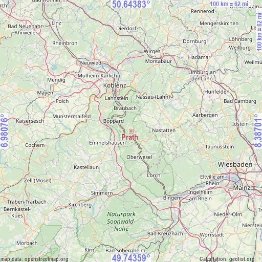
Prath GPS coordinates[2]
50° 11' 44.988" North, 7° 41' 2.004" East
| Map corner | latitude | longitude |
|---|---|---|
| Upper-left | 50.64383°, | 6.98076° |
| Center: | 50.19583°, | 7.68389° |
| Lower-right: | 49.74359°, | 8.38701° |
| Map W x H: | 100.1×100.1 km | = 62.2×62.2mi |
| max Lat: | 55.01917° ⇑59.1% North |
| Prath: | 50.19583° |
| min Lat: | ⇓40.9% South 47.40724° |
| min Long | Prath | max Long |
| 5.92978° | 7.68389° | 14.98853° |
| W 16.8%⇐ | ⇒83.2% E |
Elevation
Elevation of Prath is 269 m = 883 ft, and this is 19.9 m = 65 ft above average elevation for this country.
| Max E: |
1256 m = 4121 ft | 43.5% |
| Prath | 269 m 883 ft | |
| Avg. | 249.1 m = 817 ft | |
Min E: |
-5 m = -16 ft | 56.5% |
See also: Germany elevation on elevation.city.
Geographical zone
Prath is located in North temperate zone (between Tropic of Cancer and the Arctic Circle). Distance of this North polar circle is 1819.9 km =1130.8 mi to North.| Distance of | km | miles | from Prath |
|---|---|---|---|
| North Pole | 4425.8 | 2750.1 | to North |
| Arctic Circle | 1819.9 | 1130.8 | to North |
| Tropic Cancer | 2975.3 | 1848.8 | to South |
| Equator | 5581.3 | 3468.1 | to South |


Nearby cities:
15 places around Prath: (largest is in red/bold)
• Auel
6.7 km =4.2 mi,  118°
118°
• Dahlheim
1.8 km =1.1 mi,  28°
28°
• Eschbach
3.7 km =2.3 mi,  56°
56°
• Gemmerich
6.4 km =4 mi, 56°
• Himmighofen
6.1 km =3.8 mi,  72°
72°
• Kamp-Bornhofen
5.2 km =3.2 mi,  304°
304°
• Kestert
2.8 km =1.7 mi,  240°
240°
• Lierschied
5.7 km =3.5 mi, 124°
• Lykershausen
1.3 km =0.8 mi,  290°
290°
• Nochern
4 km =2.5 mi,  144°
144°
• Patersberg
6.2 km =3.9 mi,  145°
145°
• Sankt Goar
5.5 km =3.4 mi,  162°
162°
• Sankt Goarshausen
4.7 km =2.9 mi, 152°
• Weyer
2.7 km =1.7 mi, 120°
• Winterwerb
6 km =3.7 mi,  41°
41°
Sources, notices
• [Note1] Compared only with cities in Germany existing in our database
• [Src1] Map data: © OpenStreetMap contributors (CC-BY-SA)
• [Src2] Other city data from geonames.org with taken over terms of usage.
• [Src3] Geographical zone / Annual Mean Temperature by Robert A. Rohde @ Wikipedia
