Herzogenaurach geodata
Herzogenaurach (Bavaria) is a populated place; located in Germany in Europe/Berlin (GMT+2) time zone. With population of 23,319 people, there are 639 cities with bigger population in this country. Compared to other cities in Germany, 74.4% of cities are located further ↑North; 65.3% of cities are located further ←West and 61.7% of cities have lower elevation than Herzogenaurach. Note1
Administrative division(s):
- Level 1: Bavaria
- Level 2: Regierungsbezirk Mittelfranken
- Level 3: Landkreis Erlangen-Höchstadt
- Level 4: Herzogenaurach


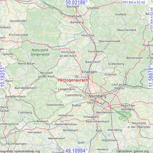
Herzogenaurach GPS coordinates[2]
49° 34' 4.728" North, 10° 53' 8.34" East
| Map corner | latitude | longitude |
|---|---|---|
| Upper-left | 50.02186°, | 10.18253° |
| Center: | 49.56798°, | 10.88565° |
| Lower-right: | 49.10984°, | 11.58878° |
| Map W x H: | 101.4×101.4 km | = 63×63mi |
| max Lat: | 55.01917° ⇑74.4% North |
| Herzogenaurach: | 49.56798° |
| min Lat: | ⇓25.6% South 47.40724° |
| min Long | Herzogenaurach | max Long |
| 5.92978° | 10.88565° | 14.98853° |
| W 65.3%⇐ | ⇒34.7% E |
Elevation
Elevation of Herzogenaurach is 300 m = 984 ft, and this is 50.9 m = 167 ft above average elevation for this country.
| Max E: |
1256 m = 4121 ft | 38.3% |
| Herzogenaurach | 300 m 984 ft | |
| Avg. | 249.1 m = 817 ft | |
Min E: |
-5 m = -16 ft | 61.7% |
See also: Germany elevation on elevation.city.
Geographical zone
Herzogenaurach is located in North temperate zone (between Tropic of Cancer and the Arctic Circle). Distance of this North polar circle is 1889.7 km =1174.2 mi to North.| Distance of | km | miles | from Herzogenaurach |
|---|---|---|---|
| North Pole | 4495.6 | 2793.4 | to North |
| Arctic Circle | 1889.7 | 1174.2 | to North |
| Tropic Cancer | 2905.5 | 1805.4 | to South |
| Equator | 5511.4 | 3424.6 | to South |


Nearby cities:
15 places around Herzogenaurach: (largest is in red/bold)
• Erlangen
9.2 km =5.7 mi,  73°
73°
• Großenseebach
7.2 km =4.5 mi,  353°
353°
• Hagenbüchach
9.4 km =5.8 mi,  245°
245°
• Heßdorf
6.8 km =4.2 mi,  14°
14°
• Langenzenn
10.6 km =6.6 mi,  219°
219°
• Möhrendorf
11 km =6.8 mi,  48°
48°
• Obermichelbach
4.4 km =2.7 mi,  157°
157°
• Oberreichenbach
8.7 km =5.4 mi,  285°
285°
• Puschendorf
6.2 km =3.9 mi, 218°
• Röttenbach
11.1 km =6.9 mi,  15°
15°
• Seukendorf
8.9 km =5.5 mi,  182°
182°
• Tuchenbach
4.8 km =3 mi,  202°
202°
• Veitsbronn
6.2 km =3.9 mi, 178°
• Weisendorf
7.5 km =4.7 mi,  324°
324°
• Wilhelmsdorf
10.7 km =6.6 mi,  267°
267°
Sources, notices
• [Note1] Compared only with cities in Germany existing in our database
• [Src1] Map data: © OpenStreetMap contributors (CC-BY-SA)
• [Src2] Other city data from geonames.org with taken over terms of usage.
• [Src3] Geographical zone / Annual Mean Temperature by Robert A. Rohde @ Wikipedia
